Ninoy geodata
Ninoy (Ilocos) is a populated place; located in Philippines in Asia/Manila (GMT+8) time zone. With population of 3,443 people, there are 2107 cities with bigger population in this country. Compared to other cities in Philippines, 85.6% of cities are located further ↓South; 95.8% of cities are located further →East and 67.4% of cities have higher elevation than Ninoy. Note1


Ninoy GPS coordinates[2]
15° 51' 34.56" North, 120° 14' 52.08" East
| Map corner | latitude | longitude |
|---|---|---|
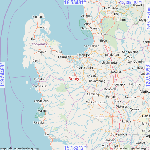
| Upper-left | 16.53481°, | 119.54468° |
| Center: | 15.8596°, | 120.2478° |
| Lower-right: | 15.18212°, | 120.95093° |
| Map W x H: | 150.4×150.4 km | = 93.5×93.5mi |
| max Lat: | 20.78733° ⇑14.4% North |
| Ninoy: | 15.8596° |
| min Lat: | ⇓85.6% South 4.65442° |
| min Long | Ninoy | max Long |
| 117.04868° | 120.2478° | 126.58417° |
| W 4.2%⇐ | ⇒95.8% E |
Elevation
Elevation of Ninoy is 13 m = 43 ft, and this is 74.9 m = 246 ft below average elevation for this country.
| Max E: |
2262 m = 7421 ft | 67.4% |
| Avg. | 87.9 m = 288 ft | |
| Ninoy | 13 m = 43 ft | |
Min E: |
-2 m = -7 ft | 32.6% |
See also: Philippines elevation on elevation.city.
Geographical zone
Ninoy is located in North Torrid zone (between Equator and Tropic of Cancer). Distance of this Northern Tropic circle is 842.5 km =523.5 mi to North.| Distance of | km | miles | from Ninoy |
|---|---|---|---|
| North Pole | 8243.6 | 5122.3 | to North |
| Arctic Circle | 5637.8 | 3503.2 | to North |
| Tropic Cancer | 842.5 | 523.5 | to North |
| Equator | 1763.4 | 1095.7 | to South |


Nearby cities:
15 places around Ninoy: (largest is in red/bold)
• Aguilar
3.4 km =2.1 mi,  341°
341°
• Bacnar
10.7 km =6.6 mi,  73°
73°
• Bayaoas
3.4 km =2.1 mi,  147°
147°
• Bugallon
10.9 km =6.8 mi, 341°
• Calsib
2.2 km =1.4 mi,  128°
128°
• Dorongan Punta
9.4 km =5.8 mi,  121°
121°
• Isla
7 km =4.3 mi,  55°
55°
• Libas
7.6 km =4.7 mi, 74°
• Linmansangan
6.1 km =3.8 mi, 122°
• Malibong East
8.6 km =5.3 mi,  99°
99°
• Mangatarem
9.3 km =5.8 mi, 149°
• Pogonsili
4.5 km =2.8 mi,  163°
163°
• Tamayo
4.4 km =2.7 mi, 63°
• Umanday Centro
9.4 km =5.8 mi, 338°
• Urbiztondo
9.7 km =6 mi, 115°
Sources, notices
• [Note1] Compared only with cities in Philippines existing in our database
• [Src1] Map data: © OpenStreetMap contributors (CC-BY-SA)
• [Src2] Other city data from geonames.org with taken over terms of usage.
• [Src3] Geographical zone / Annual Mean Temperature by Robert A. Rohde @ Wikipedia
