Nasugbu geodata
Nasugbu (Calabarzon) is a seat of a third-order administrative division; located in Philippines in Asia/Manila (GMT+8) time zone. With population of 62,857 people, there are 150 cities with bigger population in this country. Compared to other cities in Philippines, 70% of cities are located further ↓South; 87.2% of cities are located further →East and 73.2% of cities have higher elevation than Nasugbu. Note1


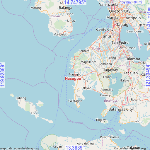
Nasugbu GPS coordinates[2]
14° 4' 0.984" North, 120° 37' 54.516" East
| Map corner | latitude | longitude |
|---|---|---|
| Upper-left | 14.74795°, | 119.92869° |
| Center: | 14.06694°, | 120.63181° |
| Lower-right: | 13.3839°, | 121.33494° |
| Map W x H: | 151.7×151.7 km | = 94.3×94.3mi |
| max Lat: | 20.78733° ⇑30% North |
| Nasugbu: | 14.06694° |
| min Lat: | ⇓70% South 4.65442° |
| min Long | Nasugbu | max Long |
| 117.04868° | 120.63181° | 126.58417° |
| W 12.8%⇐ | ⇒87.2% E |
Elevation
Elevation of Nasugbu is 11 m = 36 ft, and this is 76.9 m = 252 ft below average elevation for this country.
| Max E: |
2262 m = 7421 ft | 73.2% |
| Avg. | 87.9 m = 288 ft | |
| Nasugbu | 11 m = 36 ft | |
Min E: |
-2 m = -7 ft | 26.8% |
See also: Nasugbu elevation on elevation.city.
Geographical zone
Nasugbu is located in North Torrid zone (between Equator and Tropic of Cancer). Distance of this Northern Tropic circle is 1041.8 km =647.3 mi to North.| Distance of | km | miles | from Nasugbu |
|---|---|---|---|
| North Pole | 8443 | 5246.2 | to North |
| Arctic Circle | 5837.1 | 3627 | to North |
| Tropic Cancer | 1041.8 | 647.3 | to North |
| Equator | 1564.1 | 971.9 | to South |


Nearby cities:
15 places around Nasugbu: (largest is in red/bold)
• Banilad
11.1 km =6.9 mi,  90°
90°
• Bilaran
9.2 km =5.7 mi,  112°
112°
• Binubusan
10.8 km =6.7 mi,  177°
177°
• Bulihan
10 km =6.2 mi,  7°
7°
• Lian
4.2 km =2.6 mi,  153°
153°
• Looc
10.9 km =6.8 mi,  358°
358°
• Lumbangan
4.1 km =2.5 mi, 113°
• Luntal
10.1 km =6.3 mi, 114°
• Malaruhatan
6.6 km =4.1 mi,  127°
127°
• Mataywanac
11.3 km =7 mi, 110°
• Prinza
8.2 km =5.1 mi,  162°
162°
• Sabang
8.6 km =5.3 mi, 92°
• San Diego
2.8 km =1.7 mi,  193°
193°
• Tumalim
10 km =6.2 mi,  81°
81°
• Tuy
11.9 km =7.4 mi,  117°
117°
Sources, notices
• [Note1] Compared only with cities in Philippines existing in our database
• [Src1] Map data: © OpenStreetMap contributors (CC-BY-SA)
• [Src2] Other city data from geonames.org with taken over terms of usage.
• [Src3] Geographical zone / Annual Mean Temperature by Robert A. Rohde @ Wikipedia
