Luntal geodata
Luntal (Calabarzon) is a populated place; located in Philippines in Asia/Manila (GMT+8) time zone. With population of 2,765 people, there are 2850 cities with bigger population in this country. Compared to other cities in Philippines, 69.4% of cities are located further ↓South; 84.5% of cities are located further →East and 74.9% of cities have lower elevation than Luntal. Note1


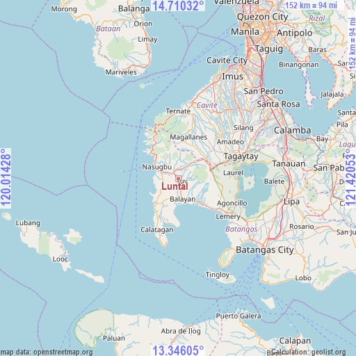
Luntal GPS coordinates[2]
14° 1' 45.12" North, 120° 43' 2.64" East
| Map corner | latitude | longitude |
|---|---|---|
| Upper-left | 14.71032°, | 120.01428° |
| Center: | 14.0292°, | 120.7174° |
| Lower-right: | 13.34605°, | 121.42053° |
| Map W x H: | 151.7×151.7 km | = 94.3×94.3mi |
| max Lat: | 20.78733° ⇑30.6% North |
| Luntal: | 14.0292° |
| min Lat: | ⇓69.4% South 4.65442° |
| min Long | Luntal | max Long |
| 117.04868° | 120.7174° | 126.58417° |
| W 15.5%⇐ | ⇒84.5% E |
Elevation
Elevation of Luntal is 68 m = 223 ft, and this is 19.9 m = 65 ft below average elevation for this country.
| Max E: |
2262 m = 7421 ft | 25.1% |
| Avg. | 87.9 m = 288 ft | |
| Luntal | 68 m = 223 ft | |
Min E: |
-2 m = -7 ft | 74.9% |
See also: Philippines elevation on elevation.city.
Geographical zone
Luntal is located in North Torrid zone (between Equator and Tropic of Cancer). Distance of this Northern Tropic circle is 1046 km =650 mi to North.| Distance of | km | miles | from Luntal |
|---|---|---|---|
| North Pole | 8447.2 | 5248.8 | to North |
| Arctic Circle | 5841.3 | 3629.6 | to North |
| Tropic Cancer | 1046 | 650 | to North |
| Equator | 1559.9 | 969.3 | to South |


Nearby cities:
15 places around Luntal: (largest is in red/bold)
• Banilad
4.6 km =2.9 mi,  24°
24°
• Bilaran
1 km =0.6 mi,  311°
311°
• Bolboc
4.3 km =2.7 mi,  102°
102°
• Calantas
8.9 km =5.5 mi,  135°
135°
• Lian
7.4 km =4.6 mi,  273°
273°
• Lumbangan
6 km =3.7 mi,  295°
295°
• Malaruhatan
4 km =2.5 mi, 272°
• Mataywanac
1.3 km =0.8 mi,  80°
80°
• Prinza
7.7 km =4.8 mi,  242°
242°
• Putol
4.3 km =2.7 mi,  165°
165°
• Sabang
3.9 km =2.4 mi,  349°
349°
• San Diego
10 km =6.2 mi,  278°
278°
• Toong
6.8 km =4.2 mi,  47°
47°
• Tumalim
5.7 km =3.5 mi,  6°
6°
• Tuy
1.8 km =1.1 mi,  132°
132°
Sources, notices
• [Note1] Compared only with cities in Philippines existing in our database
• [Src1] Map data: © OpenStreetMap contributors (CC-BY-SA)
• [Src2] Other city data from geonames.org with taken over terms of usage.
• [Src3] Geographical zone / Annual Mean Temperature by Robert A. Rohde @ Wikipedia
