Looc geodata
Looc (Calabarzon) is a populated place; located in Philippines in Asia/Manila (GMT+8) time zone. With population of 3,092 people, there are 2426 cities with bigger population in this country. Compared to other cities in Philippines, 71.3% of cities are located further ↓South; 87.2% of cities are located further →East and 70.2% of cities have higher elevation than Looc. Note1


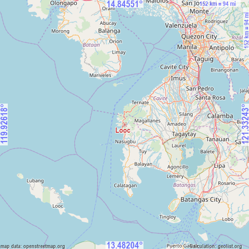
Looc GPS coordinates[2]
14° 9' 53.28" North, 120° 37' 45.48" East
| Map corner | latitude | longitude |
|---|---|---|
| Upper-left | 14.84551°, | 119.92618° |
| Center: | 14.1648°, | 120.6293° |
| Lower-right: | 13.48204°, | 121.33243° |
| Map W x H: | 151.6×151.6 km | = 94.2×94.2mi |
| max Lat: | 20.78733° ⇑28.7% North |
| Looc: | 14.1648° |
| min Lat: | ⇓71.3% South 4.65442° |
| min Long | Looc | max Long |
| 117.04868° | 120.6293° | 126.58417° |
| W 12.8%⇐ | ⇒87.2% E |
Elevation
Elevation of Looc is 12 m = 39 ft, and this is 75.9 m = 249 ft below average elevation for this country.
| Max E: |
2262 m = 7421 ft | 70.2% |
| Avg. | 87.9 m = 288 ft | |
| Looc | 12 m = 39 ft | |
Min E: |
-2 m = -7 ft | 29.8% |
See also: Philippines elevation on elevation.city.
Geographical zone
Looc is located in North Torrid zone (between Equator and Tropic of Cancer). Distance of this Northern Tropic circle is 1030.9 km =640.6 mi to North.| Distance of | km | miles | from Looc |
|---|---|---|---|
| North Pole | 8432.1 | 5239.5 | to North |
| Arctic Circle | 5826.2 | 3620.2 | to North |
| Tropic Cancer | 1030.9 | 640.6 | to North |
| Equator | 1575 | 978.7 | to South |


Nearby cities:
15 places around Looc: (largest is in red/bold)
• Banilad
15.8 km =9.8 mi,  133°
133°
• Bilaran
16.8 km =10.4 mi,  148°
148°
• Bulihan
1.9 km =1.2 mi,  121°
121°
• Lian
14.7 km =9.1 mi,  171°
171°
• Lumbangan
13.1 km =8.1 mi,  162°
162°
• Luntal
17.8 km =11.1 mi, 147°
• Magallanes
14.1 km =8.8 mi,  79°
79°
• Malaruhatan
15.9 km =9.9 mi, 159°
• Maragondon
16.8 km =10.4 mi,  44°
44°
• Nasugbu
10.9 km =6.8 mi,  178°
178°
• Sabang
14.3 km =8.9 mi,  141°
141°
• San Diego
13.6 km =8.5 mi, 181°
• Ternate
16.8 km =10.4 mi,  34°
34°
• Toong
17.8 km =11.1 mi, 125°
• Tumalim
13.8 km =8.6 mi, 132°
Sources, notices
• [Note1] Compared only with cities in Philippines existing in our database
• [Src1] Map data: © OpenStreetMap contributors (CC-BY-SA)
• [Src2] Other city data from geonames.org with taken over terms of usage.
• [Src3] Geographical zone / Annual Mean Temperature by Robert A. Rohde @ Wikipedia
