Medellin geodata
Medellin (Central Visayas) is a seat of a third-order administrative division; located in Philippines in Asia/Manila (GMT+8) time zone. With population of 11,741 people, there are 525 cities with bigger population in this country. Compared to other cities in Philippines, 55.5% of cities are located further ↑North; 70.2% of cities are located further ←West and 76.6% of cities have higher elevation than Medellin. Note1


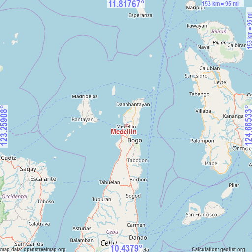
Medellin GPS coordinates[2]
11° 7' 42.96" North, 123° 57' 43.92" East
| Map corner | latitude | longitude |
|---|---|---|
| Upper-left | 11.81767°, | 123.25908° |
| Center: | 11.1286°, | 123.9622° |
| Lower-right: | 10.4379°, | 124.66533° |
| Map W x H: | 153.4×153.4 km | = 95.3×95.3mi |
| max Lat: | 20.78733° ⇑55.5% North |
| Medellin: | 11.1286° |
| min Lat: | ⇓44.5% South 4.65442° |
| min Long | Medellin | max Long |
| 117.04868° | 123.9622° | 126.58417° |
| W 70.2%⇐ | ⇒29.8% E |
Elevation
Elevation of Medellin is 10 m = 33 ft, and this is 77.9 m = 256 ft below average elevation for this country.
| Max E: |
2262 m = 7421 ft | 76.6% |
| Avg. | 87.9 m = 288 ft | |
| Medellin | 10 m = 33 ft | |
Min E: |
-2 m = -7 ft | 23.4% |
See also: Philippines elevation on elevation.city.
Geographical zone
Medellin is located in North Torrid zone (between Equator and Tropic of Cancer). Distance of Equator is 1237.4 km =768.9 mi to South.| Distance of | km | miles | from Medellin |
|---|---|---|---|
| North Pole | 8769.7 | 5449.2 | to North |
| Arctic Circle | 6163.8 | 3830 | to North |
| Tropic Cancer | 1368.5 | 850.3 | to North |
| Equator | 1237.4 | 768.9 | to South |


Nearby cities:
15 places around Medellin: (largest is in red/bold)
• Antipolo
4.4 km =2.7 mi,  342°
342°
• Bachauan
8.7 km =5.4 mi,  0°
0°
• Bateria
7.2 km =4.5 mi,  78°
78°
• Bogo
9.8 km =6.1 mi,  151°
151°
• Calape
9.4 km =5.8 mi,  56°
56°
• Cayang
7.3 km =4.5 mi,  161°
161°
• Hagnaya
4.5 km =2.8 mi,  206°
206°
• Kauit
6.6 km =4.1 mi, 344°
• Malingin
9 km =5.6 mi,  165°
165°
• Maño
9.9 km =6.2 mi,  191°
191°
• Panognawan
6 km =3.7 mi,  51°
51°
• Paypay
9.7 km =6 mi,  9°
9°
• San Remigio
5.9 km =3.7 mi, 206°
• Tindog
5.4 km =3.4 mi,  94°
94°
• Tinubuan
8.1 km =5 mi,  37°
37°
Sources, notices
• [Note1] Compared only with cities in Philippines existing in our database
• [Src1] Map data: © OpenStreetMap contributors (CC-BY-SA)
• [Src2] Other city data from geonames.org with taken over terms of usage.
• [Src3] Geographical zone / Annual Mean Temperature by Robert A. Rohde @ Wikipedia
