Panognawan geodata
Panognawan (Central Visayas) is a populated place; located in Philippines in Asia/Manila (GMT+8) time zone. With population of 2,154 people, there are 3979 cities with bigger population in this country. Compared to other cities in Philippines, 55% of cities are located further ↑North; 71% of cities are located further ←West and 78.6% of cities have lower elevation than Panognawan. Note1


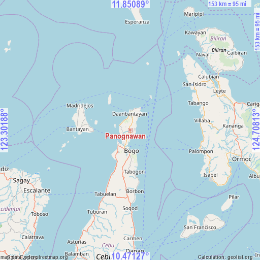
Panognawan GPS coordinates[2]
11° 9' 42.84" North, 124° 0' 18" East
| Map corner | latitude | longitude |
|---|---|---|
| Upper-left | 11.85089°, | 123.30188° |
| Center: | 11.1619°, | 124.005° |
| Lower-right: | 10.47127°, | 124.70813° |
| Map W x H: | 153.4×153.4 km | = 95.3×95.3mi |
| max Lat: | 20.78733° ⇑55% North |
| Panognawan: | 11.1619° |
| min Lat: | ⇓45% South 4.65442° |
| min Long | Panognawan | max Long |
| 117.04868° | 124.005° | 126.58417° |
| W 71%⇐ | ⇒29% E |
Elevation
Elevation of Panognawan is 83 m = 272 ft, and this is 4.9 m = 16 ft below average elevation for this country.
| Max E: |
2262 m = 7421 ft | 21.4% |
| Avg. | 87.9 m = 288 ft | |
| Panognawan | 83 m = 272 ft | |
Min E: |
-2 m = -7 ft | 78.6% |
See also: Philippines elevation on elevation.city.
Geographical zone
Panognawan is located in North Torrid zone (between Equator and Tropic of Cancer). Distance of Equator is 1241.1 km =771.2 mi to South.| Distance of | km | miles | from Panognawan |
|---|---|---|---|
| North Pole | 8766 | 5446.9 | to North |
| Arctic Circle | 6160.1 | 3827.7 | to North |
| Tropic Cancer | 1364.8 | 848 | to North |
| Equator | 1241.1 | 771.2 | to South |


Nearby cities:
15 places around Panognawan: (largest is in red/bold)
• Antipolo
6 km =3.7 mi,  275°
275°
• Bachauan
6.7 km =4.2 mi,  317°
317°
• Bagay
5 km =3.1 mi,  40°
40°
• Bateria
3.3 km =2.1 mi,  133°
133°
• Biton
7.9 km =4.9 mi,  355°
355°
• Calape
3.5 km =2.2 mi,  63°
63°
• Daanbantayan
9.5 km =5.9 mi,  6°
6°
• Hagnaya
10.2 km =6.3 mi,  220°
220°
• Kauit
7 km =4.3 mi,  292°
292°
• Medellin
6 km =3.7 mi,  231°
231°
• Pajo
8.8 km =5.5 mi,  4°
4°
• Paypay
6.7 km =4.2 mi,  332°
332°
• Tindog
4.2 km =2.6 mi,  169°
169°
• Tinubuan
2.7 km =1.7 mi, 6°
• Tominhao
8.8 km =5.5 mi,  21°
21°
Sources, notices
• [Note1] Compared only with cities in Philippines existing in our database
• [Src1] Map data: © OpenStreetMap contributors (CC-BY-SA)
• [Src2] Other city data from geonames.org with taken over terms of usage.
• [Src3] Geographical zone / Annual Mean Temperature by Robert A. Rohde @ Wikipedia
