Calape geodata
Calape (Central Visayas) is a populated place; located in Philippines in Asia/Manila (GMT+8) time zone. With population of 2,832 people, there are 2738 cities with bigger population in this country. Compared to other cities in Philippines, 54.9% of cities are located further ↑North; 71.8% of cities are located further ←West and 76.6% of cities have higher elevation than Calape. Note1
Administrative division(s):
- Level 1: Central Visayas
- Level 2: Province of Cebu
- Level 3: Daanbantayan


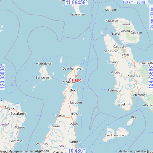
Calape GPS coordinates[2]
11° 10' 32.16" North, 124° 2' 0.6" East
| Map corner | latitude | longitude |
|---|---|---|
| Upper-left | 11.86456°, | 123.33038° |
| Center: | 11.1756°, | 124.0335° |
| Lower-right: | 10.485°, | 124.73663° |
| Map W x H: | 153.4×153.4 km | = 95.3×95.3mi |
| max Lat: | 20.78733° ⇑54.9% North |
| Calape: | 11.1756° |
| min Lat: | ⇓45.1% South 4.65442° |
| min Long | Calape | max Long |
| 117.04868° | 124.0335° | 126.58417° |
| W 71.8%⇐ | ⇒28.2% E |
Elevation
Elevation of Calape is 10 m = 33 ft, and this is 77.9 m = 256 ft below average elevation for this country.
| Max E: |
2262 m = 7421 ft | 76.6% |
| Avg. | 87.9 m = 288 ft | |
| Calape | 10 m = 33 ft | |
Min E: |
-2 m = -7 ft | 23.4% |
See also: Philippines elevation on elevation.city.
Geographical zone
Calape is located in North Torrid zone (between Equator and Tropic of Cancer). Distance of Equator is 1242.6 km =772.1 mi to South.| Distance of | km | miles | from Calape |
|---|---|---|---|
| North Pole | 8764.5 | 5446 | to North |
| Arctic Circle | 6158.6 | 3826.8 | to North |
| Tropic Cancer | 1363.3 | 847.1 | to North |
| Equator | 1242.6 | 772.1 | to South |


Nearby cities:
15 places around Calape: (largest is in red/bold)
• Antipolo
9.2 km =5.7 mi,  263°
263°
• Bachauan
8.4 km =5.2 mi,  294°
294°
• Bagay
2.3 km =1.4 mi,  4°
4°
• Bateria
3.9 km =2.4 mi,  191°
191°
• Biton
7.4 km =4.6 mi,  329°
329°
• Daanbantayan
8.2 km =5.1 mi,  345°
345°
• Lanao
9 km =5.6 mi, 353°
• Medellin
9.4 km =5.8 mi,  236°
236°
• Pajo
7.7 km =4.8 mi,  341°
341°
• Panognawan
3.5 km =2.2 mi, 243°
• Paypay
7.6 km =4.7 mi,  305°
305°
• Talisay
8.1 km =5 mi,  16°
16°
• Tindog
6.1 km =3.8 mi,  202°
202°
• Tinubuan
3 km =1.9 mi, 292°
• Tominhao
6.7 km =4.2 mi, 1°
Sources, notices
• [Note1] Compared only with cities in Philippines existing in our database
• [Src1] Map data: © OpenStreetMap contributors (CC-BY-SA)
• [Src2] Other city data from geonames.org with taken over terms of usage.
• [Src3] Geographical zone / Annual Mean Temperature by Robert A. Rohde @ Wikipedia
