Masaling geodata
Masaling (Western Visayas) is a populated place; located in Philippines in Asia/Manila (GMT+8) time zone. With population of 3,829 people, there are 1825 cities with bigger population in this country. Compared to other cities in Philippines, 68.4% of cities are located further ↑North; 53.9% of cities are located further →East and 73.2% of cities have higher elevation than Masaling. Note1
Administrative division(s):
- Level 1: Western Visayas
- Level 2: Province of Negros Occidental
- Level 3: Cauayan


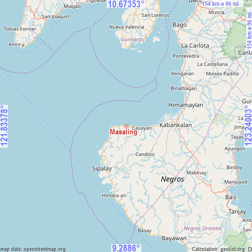
Masaling GPS coordinates[2]
9° 58' 54.48" North, 122° 32' 12.84" East
| Map corner | latitude | longitude |
|---|---|---|
| Upper-left | 10.67353°, | 121.83378° |
| Center: | 9.9818°, | 122.5369° |
| Lower-right: | 9.2886°, | 123.24003° |
| Map W x H: | 154×154 km | = 95.7×95.7mi |
| max Lat: | 20.78733° ⇑68.4% North |
| Masaling: | 9.9818° |
| min Lat: | ⇓31.6% South 4.65442° |
| min Long | Masaling | max Long |
| 117.04868° | 122.5369° | 126.58417° |
| W 46.1%⇐ | ⇒53.9% E |
Elevation
Elevation of Masaling is 11 m = 36 ft, and this is 76.9 m = 252 ft below average elevation for this country.
| Max E: |
2262 m = 7421 ft | 73.2% |
| Avg. | 87.9 m = 288 ft | |
| Masaling | 11 m = 36 ft | |
Min E: |
-2 m = -7 ft | 26.8% |
See also: Philippines elevation on elevation.city.
Geographical zone
Masaling is located in North Torrid zone (between Equator and Tropic of Cancer). Distance of Equator is 1109.9 km =689.7 mi to South.| Distance of | km | miles | from Masaling |
|---|---|---|---|
| North Pole | 8897.2 | 5528.5 | to North |
| Arctic Circle | 6291.3 | 3909.2 | to North |
| Tropic Cancer | 1496 | 929.6 | to North |
| Equator | 1109.9 | 689.7 | to South |


Nearby cities:
15 places around Masaling: (largest is in red/bold)
• Bocana
20.5 km =12.7 mi,  80°
80°
• Bulata
20.1 km =12.5 mi,  227°
227°
• Camindangan
12.4 km =7.7 mi,  124°
124°
• Candoni
19.8 km =12.3 mi,  158°
158°
• Caningay
20.6 km =12.8 mi,  145°
145°
• Canturay
22.8 km =14.2 mi,  203°
203°
• Cawayan
9.7 km =6 mi,  96°
96°
• Dancalan
22.1 km =13.7 mi,  89°
89°
• Guiljungan
15 km =9.3 mi, 90°
• Inayauan
14.4 km =8.9 mi, 231°
• Kaliling
6.1 km =3.8 mi,  268°
268°
• Linaon
10.3 km =6.4 mi,  249°
249°
• Tabu
21.4 km =13.3 mi, 117°
• Tiling
12.9 km =8 mi, 94°
• Tuyum
2.4 km =1.5 mi, 103°
Sources, notices
• [Note1] Compared only with cities in Philippines existing in our database
• [Src1] Map data: © OpenStreetMap contributors (CC-BY-SA)
• [Src2] Other city data from geonames.org with taken over terms of usage.
• [Src3] Geographical zone / Annual Mean Temperature by Robert A. Rohde @ Wikipedia
