Canturay geodata
Canturay (Western Visayas) is a populated place; located in Philippines in Asia/Manila (GMT+8) time zone. With population of 5,135 people, there are 1249 cities with bigger population in this country. Compared to other cities in Philippines, 70.4% of cities are located further ↑North; 55.6% of cities are located further →East and 51.8% of cities have higher elevation than Canturay. Note1
Administrative division(s):
- Level 1: Western Visayas
- Level 2: Province of Negros Occidental
- Level 3: City of Sipalay


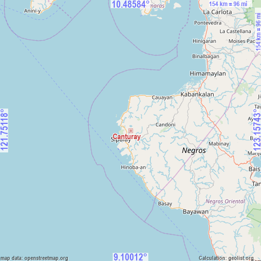
Canturay GPS coordinates[2]
9° 47' 37.32" North, 122° 27' 15.48" East
| Map corner | latitude | longitude |
|---|---|---|
| Upper-left | 10.48584°, | 121.75118° |
| Center: | 9.7937°, | 122.4543° |
| Lower-right: | 9.10012°, | 123.15743° |
| Map W x H: | 154.1×154.1 km | = 95.8×95.8mi |
| max Lat: | 20.78733° ⇑70.4% North |
| Canturay: | 9.7937° |
| min Lat: | ⇓29.6% South 4.65442° |
| min Long | Canturay | max Long |
| 117.04868° | 122.4543° | 126.58417° |
| W 44.4%⇐ | ⇒55.6% E |
Elevation
Elevation of Canturay is 22 m = 72 ft, and this is 65.9 m = 216 ft below average elevation for this country.
| Max E: |
2262 m = 7421 ft | 51.8% |
| Avg. | 87.9 m = 288 ft | |
| Canturay | 22 m = 72 ft | |
Min E: |
-2 m = -7 ft | 48.2% |
See also: Philippines elevation on elevation.city.
Geographical zone
Canturay is located in North Torrid zone (between Equator and Tropic of Cancer). Distance of Equator is 1089 km =676.7 mi to South.| Distance of | km | miles | from Canturay |
|---|---|---|---|
| North Pole | 8918.1 | 5541.4 | to North |
| Arctic Circle | 6312.2 | 3922.2 | to North |
| Tropic Cancer | 1517 | 942.6 | to North |
| Equator | 1089 | 676.7 | to South |


Nearby cities:
15 places around Canturay: (largest is in red/bold)
• Bacuyangan
17.5 km =10.9 mi,  173°
173°
• Bulata
9.4 km =5.8 mi,  321°
321°
• Cabadiangan
5 km =3.1 mi,  154°
154°
• Candoni
16.6 km =10.3 mi,  81°
81°
• Caningay
21.2 km =13.2 mi, 79°
• Cartagena
6.6 km =4.1 mi,  296°
296°
• Cayhagan
13 km =8.1 mi,  190°
190°
• Inayauan
12.1 km =7.5 mi,  349°
349°
• Kaliling
21 km =13 mi,  8°
8°
• Linaon
17.4 km =10.8 mi,  357°
357°
• Manlucahoc
7.7 km =4.8 mi,  141°
141°
• Maricalom
10.6 km =6.6 mi,  201°
201°
• Masaling
22.8 km =14.2 mi,  23°
23°
• Nabulao
14.7 km =9.1 mi,  178°
178°
• Sipalay
7.2 km =4.5 mi,  229°
229°
Sources, notices
• [Note1] Compared only with cities in Philippines existing in our database
• [Src1] Map data: © OpenStreetMap contributors (CC-BY-SA)
• [Src2] Other city data from geonames.org with taken over terms of usage.
• [Src3] Geographical zone / Annual Mean Temperature by Robert A. Rohde @ Wikipedia
