Manila geodata
Manila (Metro Manila) is a capital of a political entity; located in Philippines in Asia/Manila (GMT+8) time zone. With population of 1,600,000 people, there is 1 city with bigger population in this country. Compared to other cities in Philippines, 74.6% of cities are located further ↓South; 76.7% of cities are located further →East and 67.4% of cities have higher elevation than Manila. Note1


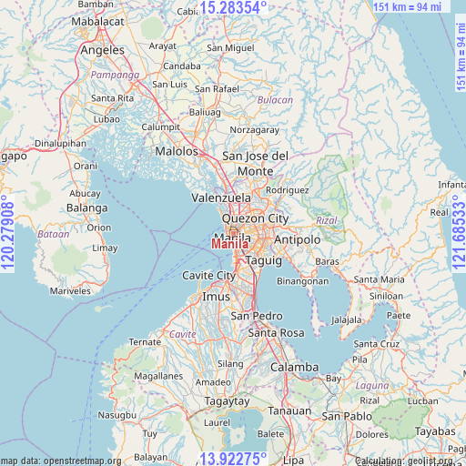
Manila GPS coordinates[2]
14° 36' 15.12" North, 120° 58' 55.92" East
| Map corner | latitude | longitude |
|---|---|---|
| Upper-left | 15.28354°, | 120.27908° |
| Center: | 14.6042°, | 120.9822° |
| Lower-right: | 13.92275°, | 121.68533° |
| Map W x H: | 151.3×151.3 km | = 94×94mi |
| max Lat: | 20.78733° ⇑25.4% North |
| Manila: | 14.6042° |
| min Lat: | ⇓74.6% South 4.65442° |
| min Long | Manila | max Long |
| 117.04868° | 120.9822° | 126.58417° |
| W 23.3%⇐ | ⇒76.7% E |
Elevation
Elevation of Manila is 13 m = 43 ft, and this is 74.9 m = 246 ft below average elevation for this country.
| Max E: |
2262 m = 7421 ft | 67.4% |
| Avg. | 87.9 m = 288 ft | |
| Manila | 13 m = 43 ft | |
Min E: |
-2 m = -7 ft | 32.6% |
See also: Manila elevation on elevation.city.
Geographical zone
Manila is located in North Torrid zone (between Equator and Tropic of Cancer). Distance of this Northern Tropic circle is 982.1 km =610.2 mi to North.| Distance of | km | miles | from Manila |
|---|---|---|---|
| North Pole | 8383.2 | 5209.1 | to North |
| Arctic Circle | 5777.3 | 3589.8 | to North |
| Tropic Cancer | 982.1 | 610.2 | to North |
| Equator | 1623.8 | 1009 | to South |


Nearby cities:
15 places around Manila: (largest is in red/bold)
• Bagong Pagasa
8.5 km =5.3 mi,  39°
39°
• Caloocan City
5.3 km =3.3 mi,  343°
343°
• Del Monte
5.7 km =3.5 mi, 42°
• Makati City
8.1 km =5 mi,  137°
137°
• Malabon
8.9 km =5.5 mi,  329°
329°
• Mandaluyong City
6.7 km =4.2 mi,  110°
110°
• Navotas
7.8 km =4.8 mi, 333°
• Niugan
7.3 km =4.5 mi, 336°
• Pasay
7.7 km =4.8 mi,  164°
164°
• Pasig City
8.7 km =5.4 mi,  102°
102°
• Port Area
2.9 km =1.8 mi,  215°
215°
• Quezon City
8.9 km =5.5 mi,  56°
56°
• Quiapo
0.5 km =0.3 mi,  165°
165°
• San Juan
5.5 km =3.4 mi,  94°
94°
• Tanza
9.2 km =5.7 mi, 329°
Sources, notices
• [Note1] Compared only with cities in Philippines existing in our database
• [Src1] Map data: © OpenStreetMap contributors (CC-BY-SA)
• [Src2] Other city data from geonames.org with taken over terms of usage.
• [Src3] Geographical zone / Annual Mean Temperature by Robert A. Rohde @ Wikipedia
