Pasay geodata
Pasay (Metro Manila) is a populated place; located in Philippines in Asia/Manila (GMT+8) time zone. With population of 416,522 people, there are 18 cities with bigger population in this country. Compared to other cities in Philippines, 74.2% of cities are located further ↓South; 76.3% of cities are located further →East and 80.7% of cities have higher elevation than Pasay. Note1
Administrative division(s):
- Level 1: Metro Manila
- Level 2: Southern Manila District
- Level 3: Pasay City


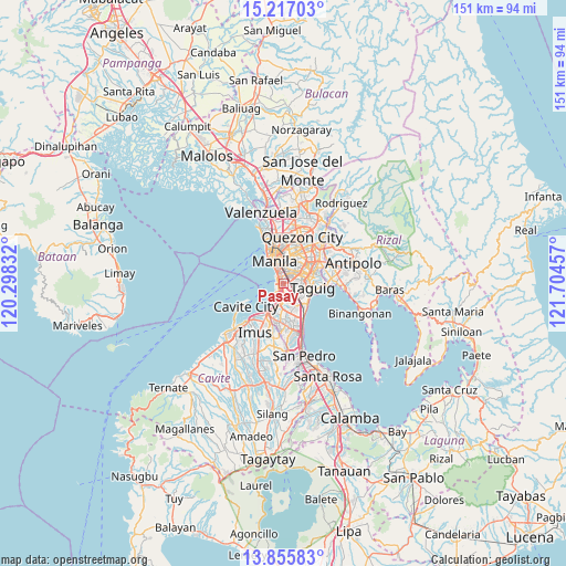
Pasay GPS coordinates[2]
14° 32' 14.928" North, 121° 0' 5.184" East
| Map corner | latitude | longitude |
|---|---|---|
| Upper-left | 15.21703°, | 120.29832° |
| Center: | 14.53748°, | 121.00144° |
| Lower-right: | 13.85583°, | 121.70457° |
| Map W x H: | 151.4×151.4 km | = 94.1×94.1mi |
| max Lat: | 20.78733° ⇑25.8% North |
| Pasay: | 14.53748° |
| min Lat: | ⇓74.2% South 4.65442° |
| min Long | Pasay | max Long |
| 117.04868° | 121.00144° | 126.58417° |
| W 23.7%⇐ | ⇒76.3% E |
Elevation
Elevation of Pasay is 9 m = 30 ft, and this is 78.9 m = 259 ft below average elevation for this country.
| Max E: |
2262 m = 7421 ft | 80.7% |
| Avg. | 87.9 m = 288 ft | |
| Pasay | 9 m = 30 ft | |
Min E: |
-2 m = -7 ft | 19.3% |
See also: Pasay elevation on elevation.city.
Geographical zone
Pasay is located in North Torrid zone (between Equator and Tropic of Cancer). Distance of this Northern Tropic circle is 989.5 km =614.8 mi to North.| Distance of | km | miles | from Pasay |
|---|---|---|---|
| North Pole | 8390.6 | 5213.7 | to North |
| Arctic Circle | 5784.8 | 3594.5 | to North |
| Tropic Cancer | 989.5 | 614.8 | to North |
| Equator | 1616.4 | 1004.4 | to South |


Nearby cities:
15 places around Pasay: (largest is in red/bold)
• Bacoor
11.1 km =6.9 mi,  217°
217°
• Caloocan City
13 km =8.1 mi,  343°
343°
• Cavite City
12.6 km =7.8 mi,  241°
241°
• Del Monte
11.7 km =7.3 mi,  8°
8°
• Las Piñas
9.9 km =6.2 mi,  191°
191°
• Makati City
3.7 km =2.3 mi,  67°
67°
• Mandaluyong City
6.6 km =4.1 mi,  39°
39°
• Manila
7.7 km =4.8 mi, 344°
• Pasig City
8.5 km =5.3 mi,  49°
49°
• Pateros
7.7 km =4.8 mi,  88°
88°
• Port Area
6.3 km =3.9 mi,  323°
323°
• Quiapo
7.2 km =4.5 mi, 344°
• Sambayanihan People's Village
9.1 km =5.7 mi,  182°
182°
• San Juan
7.8 km =4.8 mi,  26°
26°
• Taguig
8.5 km =5.3 mi,  99°
99°
Sources, notices
• [Note1] Compared only with cities in Philippines existing in our database
• [Src1] Map data: © OpenStreetMap contributors (CC-BY-SA)
• [Src2] Other city data from geonames.org with taken over terms of usage.
• [Src3] Geographical zone / Annual Mean Temperature by Robert A. Rohde @ Wikipedia
