Mankayan geodata
Mankayan (Cordillera) is a seat of a third-order administrative division; located in Philippines in Asia/Manila (GMT+8) time zone. With population of 15,886 people, there are 428 cities with bigger population in this country. Compared to other cities in Philippines, 92.7% of cities are located further ↓South; 82.7% of cities are located further →East and 99.3% of cities have lower elevation than Mankayan. Note1


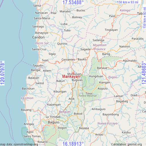
Mankayan GPS coordinates[2]
16° 51' 47.52" North, 120° 46' 58.44" East
| Map corner | latitude | longitude |
|---|---|---|
| Upper-left | 17.53488°, | 120.07978° |
| Center: | 16.8632°, | 120.7829° |
| Lower-right: | 16.18913°, | 121.48603° |
| Map W x H: | 149.6×149.6 km | = 93×93mi |
| max Lat: | 20.78733° ⇑7.3% North |
| Mankayan: | 16.8632° |
| min Lat: | ⇓92.7% South 4.65442° |
| min Long | Mankayan | max Long |
| 117.04868° | 120.7829° | 126.58417° |
| W 17.3%⇐ | ⇒82.7% E |
Elevation
Elevation of Mankayan is 1203 m = 3947 ft, and this is 1115.1 m = 3658 ft above average elevation for this country.
| Max E: |
2262 m = 7421 ft | 0.7% |
| Mankayan | 1203 m 3947 ft | |
| Avg. | 87.9 m = 288 ft | |
Min E: |
-2 m = -7 ft | 99.3% |
See also: Philippines elevation on elevation.city.
Geographical zone
Mankayan is located in North Torrid zone (between Equator and Tropic of Cancer). Distance of this Northern Tropic circle is 730.9 km =454.2 mi to North.| Distance of | km | miles | from Mankayan |
|---|---|---|---|
| North Pole | 8132 | 5053 | to North |
| Arctic Circle | 5526.2 | 3433.8 | to North |
| Tropic Cancer | 730.9 | 454.2 | to North |
| Equator | 1875 | 1165.1 | to South |


Nearby cities:
15 places around Mankayan: (largest is in red/bold)
• Ampusungan
11.1 km =6.9 mi,  213°
213°
• Baculongan
8.8 km =5.5 mi,  142°
142°
• Bakun
15.2 km =9.4 mi,  237°
237°
• Bangao
7.7 km =4.8 mi,  127°
127°
• Buguias
16.4 km =10.2 mi,  162°
162°
• Bulalacao
4.1 km =2.5 mi, 138°
• Cervantes
15.1 km =9.4 mi,  340°
340°
• Comillas Norte
11.3 km =7 mi, 340°
• Dalipey
10 km =6.2 mi,  225°
225°
• Gambang
12.6 km =7.8 mi,  179°
179°
• Guinsadan
14.4 km =8.9 mi,  38°
38°
• Monamon
10.9 km =6.8 mi,  78°
78°
• Sadsadan
11.8 km =7.3 mi,  48°
48°
• Tabio
2.3 km =1.4 mi, 128°
• Tadian
15.2 km =9.4 mi,  15°
15°
Sources, notices
• [Note1] Compared only with cities in Philippines existing in our database
• [Src1] Map data: © OpenStreetMap contributors (CC-BY-SA)
• [Src2] Other city data from geonames.org with taken over terms of usage.
• [Src3] Geographical zone / Annual Mean Temperature by Robert A. Rohde @ Wikipedia
