Comillas Norte geodata
Comillas Norte (Ilocos) is a populated place; located in Philippines in Asia/Manila (GMT+8) time zone. With population of 3,148 people, there are 2363 cities with bigger population in this country. Compared to other cities in Philippines, 93.3% of cities are located further ↓South; 83.7% of cities are located further →East and 96.1% of cities have lower elevation than Comillas Norte. Note1


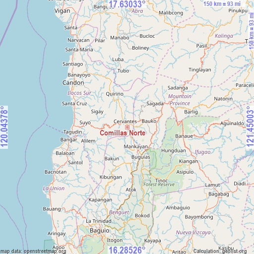
Comillas Norte GPS coordinates[2]
16° 57' 32.4" North, 120° 44' 48.84" East
| Map corner | latitude | longitude |
|---|---|---|
| Upper-left | 17.63033°, | 120.04378° |
| Center: | 16.959°, | 120.7469° |
| Lower-right: | 16.28526°, | 121.45003° |
| Map W x H: | 149.6×149.6 km | = 93×93mi |
| max Lat: | 20.78733° ⇑6.7% North |
| Comillas Norte: | 16.959° |
| min Lat: | ⇓93.3% South 4.65442° |
| min Long | Comillas Norte | max Long |
| 117.04868° | 120.7469° | 126.58417° |
| W 16.3%⇐ | ⇒83.7% E |
Elevation
Elevation of Comillas Norte is 515 m = 1690 ft, and this is 427.1 m = 1401 ft above average elevation for this country.
| Max E: |
2262 m = 7421 ft | 3.9% |
| Comillas Norte | 515 m 1690 ft | |
| Avg. | 87.9 m = 288 ft | |
Min E: |
-2 m = -7 ft | 96.1% |
See also: Philippines elevation on elevation.city.
Geographical zone
Comillas Norte is located in North Torrid zone (between Equator and Tropic of Cancer). Distance of this Northern Tropic circle is 720.3 km =447.6 mi to North.| Distance of | km | miles | from Comillas Norte |
|---|---|---|---|
| North Pole | 8121.4 | 5046.4 | to North |
| Arctic Circle | 5515.5 | 3427.2 | to North |
| Tropic Cancer | 720.3 | 447.6 | to North |
| Equator | 1885.7 | 1171.7 | to South |


Nearby cities:
15 places around Comillas Norte: (largest is in red/bold)
• Ampusungan
20 km =12.4 mi,  186°
186°
• Baculongan
19.9 km =12.4 mi,  152°
152°
• Bangao
18.3 km =11.4 mi, 147°
• Bauko
13.2 km =8.2 mi,  75°
75°
• Besao
19.2 km =11.9 mi,  37°
37°
• Bulalacao
15.2 km =9.4 mi, 154°
• Cervantes
3.7 km =2.3 mi,  341°
341°
• Dalipey
18 km =11.2 mi, 190°
• Guinsadan
12.9 km =8 mi,  87°
87°
• Mankayan
11.3 km =7 mi,  160°
160°
• Monamon
16.8 km =10.4 mi,  120°
120°
• Sabangan
19.4 km =12.1 mi, 75°
• Sadsadan
13.1 km =8.1 mi,  102°
102°
• Tabio
13.4 km =8.3 mi, 155°
• Tadian
8.8 km =5.5 mi,  62°
62°
Sources, notices
• [Note1] Compared only with cities in Philippines existing in our database
• [Src1] Map data: © OpenStreetMap contributors (CC-BY-SA)
• [Src2] Other city data from geonames.org with taken over terms of usage.
• [Src3] Geographical zone / Annual Mean Temperature by Robert A. Rohde @ Wikipedia
