Maigo geodata
Maigo (Northern Mindanao) is a populated place; located in Philippines in Asia/Manila (GMT+8) time zone. With population of 7,235 people, there are 866 cities with bigger population in this country. Compared to other cities in Philippines, 81.2% of cities are located further ↑North; 70.2% of cities are located further ←West and 89.7% of cities have higher elevation than Maigo. Note1
Administrative division(s):
- Level 1: Northern Mindanao
- Level 2: Province of Lanao del Norte
- Level 3: Maigo


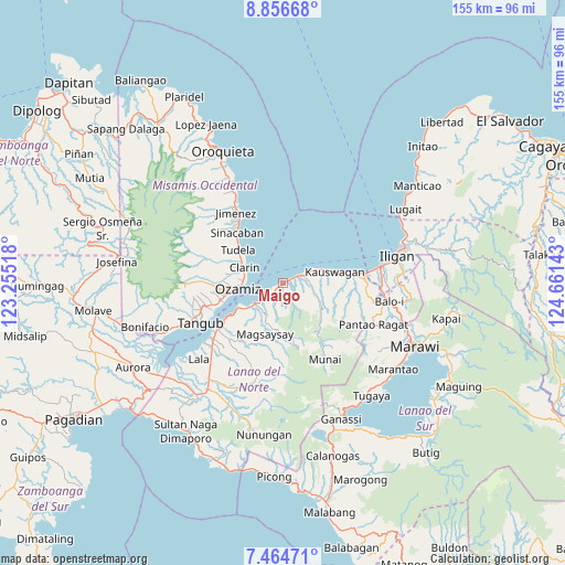
Maigo GPS coordinates[2]
8° 9' 40.68" North, 123° 57' 29.88" East
| Map corner | latitude | longitude |
|---|---|---|
| Upper-left | 8.85668°, | 123.25518° |
| Center: | 8.1613°, | 123.9583° |
| Lower-right: | 7.46471°, | 124.66143° |
| Map W x H: | 154.8×154.8 km | = 96.2×96.2mi |
| max Lat: | 20.78733° ⇑81.2% North |
| Maigo: | 8.1613° |
| min Lat: | ⇓18.8% South 4.65442° |
| min Long | Maigo | max Long |
| 117.04868° | 123.9583° | 126.58417° |
| W 70.2%⇐ | ⇒29.8% E |
Elevation
Elevation of Maigo is 7 m = 23 ft, and this is 80.9 m = 265 ft below average elevation for this country.
| Max E: |
2262 m = 7421 ft | 89.7% |
| Avg. | 87.9 m = 288 ft | |
| Maigo | 7 m = 23 ft | |
Min E: |
-2 m = -7 ft | 10.3% |
See also: Philippines elevation on elevation.city.
Geographical zone
Maigo is located in North Torrid zone (between Equator and Tropic of Cancer). Distance of Equator is 907.5 km =563.9 mi to South.| Distance of | km | miles | from Maigo |
|---|---|---|---|
| North Pole | 9099.6 | 5654.2 | to North |
| Arctic Circle | 6493.7 | 4035 | to North |
| Tropic Cancer | 1698.5 | 1055.4 | to North |
| Equator | 907.5 | 563.9 | to South |


Nearby cities:
15 places around Maigo: (largest is in red/bold)
• Bacolod
6.8 km =4.2 mi,  222°
222°
• Bagakay
15.8 km =9.8 mi,  263°
263°
• Clarin
11.9 km =7.4 mi,  292°
292°
• Dimaluna
18 km =11.2 mi, 255°
• Esperanza
5.8 km =3.6 mi,  68°
68°
• Kauswagan
14.3 km =8.9 mi,  76°
76°
• Kawit
12.3 km =7.6 mi, 76°
• Kolambugan
8.5 km =5.3 mi,  232°
232°
• Lapase
11 km =6.8 mi, 288°
• Libertad
18.3 km =11.4 mi,  313°
313°
• Ozamiz City
13 km =8.1 mi, 263°
• Pan-an
14.5 km =9 mi,  296°
296°
• Sinacaban
19.1 km =11.9 mi,  316°
316°
• Tacub
16.7 km =10.4 mi, 79°
• Tudela
15.9 km =9.9 mi, 306°
Sources, notices
• [Note1] Compared only with cities in Philippines existing in our database
• [Src1] Map data: © OpenStreetMap contributors (CC-BY-SA)
• [Src2] Other city data from geonames.org with taken over terms of usage.
• [Src3] Geographical zone / Annual Mean Temperature by Robert A. Rohde @ Wikipedia
