Kolambugan geodata
Kolambugan (Northern Mindanao) is a populated place; located in Philippines in Asia/Manila (GMT+8) time zone. With population of 2,427 people, there are 3420 cities with bigger population in this country. Compared to other cities in Philippines, 81.6% of cities are located further ↑North; 69.3% of cities are located further ←West and 85.4% of cities have higher elevation than Kolambugan. Note1


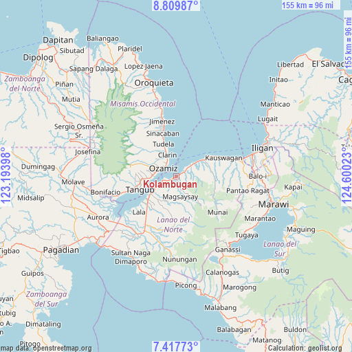
Kolambugan GPS coordinates[2]
8° 6' 51.84" North, 123° 53' 49.56" East
| Map corner | latitude | longitude |
|---|---|---|
| Upper-left | 8.80987°, | 123.19398° |
| Center: | 8.1144°, | 123.8971° |
| Lower-right: | 7.41773°, | 124.60023° |
| Map W x H: | 154.8×154.8 km | = 96.2×96.2mi |
| max Lat: | 20.78733° ⇑81.6% North |
| Kolambugan: | 8.1144° |
| min Lat: | ⇓18.4% South 4.65442° |
| min Long | Kolambugan | max Long |
| 117.04868° | 123.8971° | 126.58417° |
| W 69.3%⇐ | ⇒30.7% E |
Elevation
Elevation of Kolambugan is 8 m = 26 ft, and this is 79.9 m = 262 ft below average elevation for this country.
| Max E: |
2262 m = 7421 ft | 85.4% |
| Avg. | 87.9 m = 288 ft | |
| Kolambugan | 8 m = 26 ft | |
Min E: |
-2 m = -7 ft | 14.6% |
See also: Philippines elevation on elevation.city.
Geographical zone
Kolambugan is located in North Torrid zone (between Equator and Tropic of Cancer). Distance of Equator is 902.2 km =560.6 mi to South.| Distance of | km | miles | from Kolambugan |
|---|---|---|---|
| North Pole | 9104.8 | 5657.5 | to North |
| Arctic Circle | 6498.9 | 4038.2 | to North |
| Tropic Cancer | 1703.7 | 1058.6 | to North |
| Equator | 902.2 | 560.6 | to South |


Nearby cities:
15 places around Kolambugan: (largest is in red/bold)
• Bacolod
2.2 km =1.4 mi,  83°
83°
• Bagakay
9.6 km =6 mi,  291°
291°
• Baroy
16.3 km =10.1 mi,  233°
233°
• Clarin
10.7 km =6.6 mi,  336°
336°
• Dimaluna
10.8 km =6.7 mi,  274°
274°
• Esperanza
14.2 km =8.8 mi,  58°
58°
• Lapase
9.4 km =5.8 mi, 336°
• Maigo
8.5 km =5.3 mi,  52°
52°
• Ozamiz City
7.3 km =4.5 mi,  301°
301°
• Pan-an
13.2 km =8.2 mi,  331°
331°
• Pualas
12.1 km =7.5 mi,  206°
206°
• Tabid
12.9 km =8 mi, 267°
• Tangub
17.5 km =10.9 mi,  250°
250°
• Tubod
13.4 km =8.3 mi,  240°
240°
• Tudela
15.9 km =9.9 mi, 337°
Sources, notices
• [Note1] Compared only with cities in Philippines existing in our database
• [Src1] Map data: © OpenStreetMap contributors (CC-BY-SA)
• [Src2] Other city data from geonames.org with taken over terms of usage.
• [Src3] Geographical zone / Annual Mean Temperature by Robert A. Rohde @ Wikipedia
