Tudela geodata
Tudela (Northern Mindanao) is a populated place; located in Philippines in Asia/Manila (GMT+8) time zone. With population of 3,137 people, there are 2374 cities with bigger population in this country. Compared to other cities in Philippines, 80.5% of cities are located further ↑North; 68.5% of cities are located further ←West and 54.5% of cities have higher elevation than Tudela. Note1
Administrative division(s):
- Level 1: Northern Mindanao
- Level 2: Province of Misamis Occidental
- Level 3: Tudela


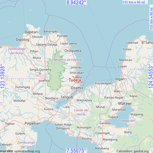
Tudela GPS coordinates[2]
8° 14' 49.92" North, 123° 50' 32.64" East
| Map corner | latitude | longitude |
|---|---|---|
| Upper-left | 8.94242°, | 123.13928° |
| Center: | 8.2472°, | 123.8424° |
| Lower-right: | 7.55075°, | 124.54553° |
| Map W x H: | 154.7×154.7 km | = 96.1×96.1mi |
| max Lat: | 20.78733° ⇑80.5% North |
| Tudela: | 8.2472° |
| min Lat: | ⇓19.5% South 4.65442° |
| min Long | Tudela | max Long |
| 117.04868° | 123.8424° | 126.58417° |
| W 68.5%⇐ | ⇒31.5% E |
Elevation
Elevation of Tudela is 20 m = 66 ft, and this is 67.9 m = 223 ft below average elevation for this country.
| Max E: |
2262 m = 7421 ft | 54.5% |
| Avg. | 87.9 m = 288 ft | |
| Tudela | 20 m = 66 ft | |
Min E: |
-2 m = -7 ft | 45.5% |
See also: Philippines elevation on elevation.city.
Geographical zone
Tudela is located in North Torrid zone (between Equator and Tropic of Cancer). Distance of Equator is 917 km =569.8 mi to South.| Distance of | km | miles | from Tudela |
|---|---|---|---|
| North Pole | 9090.1 | 5648.3 | to North |
| Arctic Circle | 6484.2 | 4029.1 | to North |
| Tropic Cancer | 1688.9 | 1049.4 | to North |
| Equator | 917 | 569.8 | to South |


Nearby cities:
15 places around Tudela: (largest is in red/bold)
• Bacolod
16.7 km =10.4 mi,  150°
150°
• Bagakay
11.7 km =7.3 mi,  194°
194°
• Clarin
5.3 km =3.3 mi,  160°
160°
• Dimaluna
14.7 km =9.1 mi,  198°
198°
• Jimenez
9.9 km =6.2 mi,  357°
357°
• Kolambugan
15.9 km =9.9 mi, 157°
• Lapase
6.5 km =4 mi, 159°
• Libertad
3.2 km =2 mi,  351°
351°
• Maigo
15.9 km =9.9 mi,  126°
126°
• Ozamiz City
11 km =6.8 mi,  181°
181°
• Pan-an
3.1 km =1.9 mi, 184°
• Sinacaban
4.4 km =2.7 mi, 356°
• Sinonoc
7 km =4.3 mi,  3°
3°
• Tabid
16.9 km =10.5 mi, 203°
• Tubao
9.7 km =6 mi,  7°
7°
Sources, notices
• [Note1] Compared only with cities in Philippines existing in our database
• [Src1] Map data: © OpenStreetMap contributors (CC-BY-SA)
• [Src2] Other city data from geonames.org with taken over terms of usage.
• [Src3] Geographical zone / Annual Mean Temperature by Robert A. Rohde @ Wikipedia
