Toong geodata
Toong (Calabarzon) is a populated place; located in Philippines in Asia/Manila (GMT+8) time zone. With population of 2,684 people, there are 2971 cities with bigger population in this country. Compared to other cities in Philippines, 70.1% of cities are located further ↓South; 83.4% of cities are located further →East and 89% of cities have lower elevation than Toong. Note1


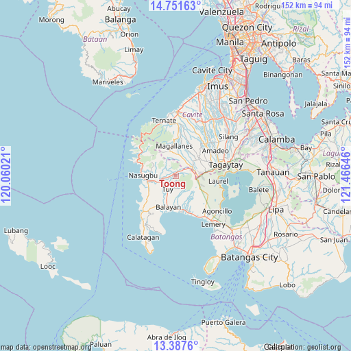
Toong GPS coordinates[2]
14° 4' 14.268" North, 120° 45' 47.988" East
| Map corner | latitude | longitude |
|---|---|---|
| Upper-left | 14.75163°, | 120.06021° |
| Center: | 14.07063°, | 120.76333° |
| Lower-right: | 13.3876°, | 121.46646° |
| Map W x H: | 151.7×151.7 km | = 94.3×94.3mi |
| max Lat: | 20.78733° ⇑29.9% North |
| Toong: | 14.07063° |
| min Lat: | ⇓70.1% South 4.65442° |
| min Long | Toong | max Long |
| 117.04868° | 120.76333° | 126.58417° |
| W 16.6%⇐ | ⇒83.4% E |
Elevation
Elevation of Toong is 200 m = 656 ft, and this is 112.1 m = 368 ft above average elevation for this country.
| Max E: |
2262 m = 7421 ft | 11% |
| Toong | 200 m 656 ft | |
| Avg. | 87.9 m = 288 ft | |
Min E: |
-2 m = -7 ft | 89% |
See also: Philippines elevation on elevation.city.
Geographical zone
Toong is located in North Torrid zone (between Equator and Tropic of Cancer). Distance of this Northern Tropic circle is 1041.4 km =647.1 mi to North.| Distance of | km | miles | from Toong |
|---|---|---|---|
| North Pole | 8442.6 | 5246 | to North |
| Arctic Circle | 5836.7 | 3626.8 | to North |
| Tropic Cancer | 1041.4 | 647.1 | to North |
| Equator | 1564.5 | 972.1 | to South |


Nearby cities:
15 places around Toong: (largest is in red/bold)
• Aga
5.1 km =3.2 mi,  55°
55°
• Banilad
3.1 km =1.9 mi,  261°
261°
• Bilaran
6.9 km =4.3 mi,  235°
235°
• Bolboc
5.6 km =3.5 mi,  188°
188°
• Calantas
11 km =6.8 mi,  173°
173°
• Kaytitinga
8.2 km =5.1 mi, 60°
• Lumbangan
10.6 km =6.6 mi, 258°
• Luntal
6.8 km =4.2 mi,  227°
227°
• Malaruhatan
10 km =6.2 mi, 243°
• Matagbak
10.2 km =6.3 mi,  49°
49°
• Mataywanac
5.7 km =3.5 mi,  219°
219°
• Putol
9.5 km =5.9 mi,  203°
203°
• Sabang
5.7 km =3.5 mi, 261°
• Tumalim
4.5 km =2.8 mi,  283°
283°
• Tuy
6.9 km =4.3 mi,  212°
212°
Sources, notices
• [Note1] Compared only with cities in Philippines existing in our database
• [Src1] Map data: © OpenStreetMap contributors (CC-BY-SA)
• [Src2] Other city data from geonames.org with taken over terms of usage.
• [Src3] Geographical zone / Annual Mean Temperature by Robert A. Rohde @ Wikipedia
