Calantas geodata
Calantas (Calabarzon) is a populated place; located in Philippines in Asia/Manila (GMT+8) time zone. With population of 2,564 people, there are 3178 cities with bigger population in this country. Compared to other cities in Philippines, 68.7% of cities are located further ↓South; 82.9% of cities are located further →East and 77.7% of cities have lower elevation than Calantas. Note1


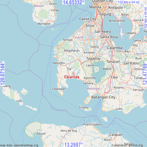
Calantas GPS coordinates[2]
13° 58' 19.272" North, 120° 46' 28.416" East
| Map corner | latitude | longitude |
|---|---|---|
| Upper-left | 14.65332°, | 120.07144° |
| Center: | 13.97202°, | 120.77456° |
| Lower-right: | 13.2887°, | 121.47769° |
| Map W x H: | 151.7×151.7 km | = 94.3×94.3mi |
| max Lat: | 20.78733° ⇑31.3% North |
| Calantas: | 13.97202° |
| min Lat: | ⇓68.7% South 4.65442° |
| min Long | Calantas | max Long |
| 117.04868° | 120.77456° | 126.58417° |
| W 17.1%⇐ | ⇒82.9% E |
Elevation
Elevation of Calantas is 79 m = 259 ft, and this is 8.9 m = 29 ft below average elevation for this country.
| Max E: |
2262 m = 7421 ft | 22.3% |
| Avg. | 87.9 m = 288 ft | |
| Calantas | 79 m = 259 ft | |
Min E: |
-2 m = -7 ft | 77.7% |
See also: Philippines elevation on elevation.city.
Geographical zone
Calantas is located in North Torrid zone (between Equator and Tropic of Cancer). Distance of this Northern Tropic circle is 1052.4 km =653.9 mi to North.| Distance of | km | miles | from Calantas |
|---|---|---|---|
| North Pole | 8453.5 | 5252.8 | to North |
| Arctic Circle | 5847.6 | 3633.5 | to North |
| Tropic Cancer | 1052.4 | 653.9 | to North |
| Equator | 1553.5 | 965.3 | to South |


Nearby cities:
15 places around Calantas: (largest is in red/bold)
• Balayan
6 km =3.7 mi,  229°
229°
• Banilad
11.4 km =7.1 mi,  337°
337°
• Bilaran
9.9 km =6.2 mi,  315°
315°
• Bolboc
5.8 km =3.6 mi, 339°
• Bungahan
12.6 km =7.8 mi,  255°
255°
• Calaca
6.1 km =3.8 mi,  136°
136°
• Luntal
8.9 km =5.5 mi, 315°
• Malaruhatan
12.1 km =7.5 mi,  302°
302°
• Mataywanac
8.2 km =5.1 mi, 323°
• Payapa
13 km =8.1 mi,  77°
77°
• Putol
5.6 km =3.5 mi,  293°
293°
• Sabang
12.2 km =7.6 mi,  326°
326°
• Sinisian
9.8 km =6.1 mi,  129°
129°
• Toong
11 km =6.8 mi,  353°
353°
• Tuy
7.1 km =4.4 mi, 316°
Sources, notices
• [Note1] Compared only with cities in Philippines existing in our database
• [Src1] Map data: © OpenStreetMap contributors (CC-BY-SA)
• [Src2] Other city data from geonames.org with taken over terms of usage.
• [Src3] Geographical zone / Annual Mean Temperature by Robert A. Rohde @ Wikipedia
