Lookan geodata
Lookan (Autonomous Region in Muslim Mindanao) is a populated place; located in Philippines in Asia/Manila (GMT+8) time zone. With population of 2,758 people, there are 2858 cities with bigger population in this country. Compared to other cities in Philippines, 99.7% of cities are located further ↑North; 96.5% of cities are located further →East and 99.6% of cities have higher elevation than Lookan. Note1
Administrative division(s):
- Level 1: Autonomous Region in Muslim Mindanao
- Level 2: Province of Tawi-Tawi


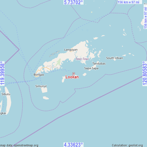
Lookan GPS coordinates[2]
5° 2' 13.2" North, 120° 6' 9.72" East
| Map corner | latitude | longitude |
|---|---|---|
| Upper-left | 5.73702°, | 119.39958° |
| Center: | 5.037°, | 120.1027° |
| Lower-right: | 4.33623°, | 120.80583° |
| Map W x H: | 155.8×155.8 km | = 96.8×96.8mi |
| max Lat: | 20.78733° ⇑99.7% North |
| Lookan: | 5.037° |
| min Lat: | ⇓0.3% South 4.65442° |
| min Long | Lookan | max Long |
| 117.04868° | 120.1027° | 126.58417° |
| W 3.5%⇐ | ⇒96.5% E |
Elevation
Elevation of Lookan is 1 m = 3 ft, and this is 86.9 m = 285 ft below average elevation for this country.
| Max E: |
2262 m = 7421 ft | 99.6% |
| Avg. | 87.9 m = 288 ft | |
| Lookan | 1 m = 3 ft | |
Min E: |
-2 m = -7 ft | 0.4% |
See also: Philippines elevation on elevation.city.
Geographical zone
Lookan is located in North Torrid zone (between Equator and Tropic of Cancer). Distance of Equator is 560.1 km =348 mi to South.| Distance of | km | miles | from Lookan |
|---|---|---|---|
| North Pole | 9447 | 5870.1 | to North |
| Arctic Circle | 6841.1 | 4250.9 | to North |
| Tropic Cancer | 2045.9 | 1271.3 | to North |
| Equator | 560.1 | 348 | to South |


Nearby cities:
15 places around Lookan: (largest is in red/bold)
• Bakung
37.8 km =23.5 mi,  244°
244°
• Balimbing
16 km =9.9 mi,  288°
288°
• Bankaw
10.6 km =6.6 mi,  259°
259°
• Bongao
36.5 km =22.7 mi,  268°
268°
• Buan
15.3 km =9.5 mi,  334°
334°
• Kolape
23.1 km =14.4 mi,  279°
279°
• Languyan
25.1 km =15.6 mi,  354°
354°
• New Batu Batu
24.5 km =15.2 mi, 277°
• Parangan
18.9 km =11.7 mi, 285°
• Sanga-Sanga
35.4 km =22 mi, 276°
• Sapa
27.8 km =17.3 mi,  61°
61°
• Simunul
32 km =19.9 mi, 241°
• Tampakan
36.5 km =22.7 mi,  249°
249°
• Tongouson
3.8 km =2.4 mi,  117°
117°
• Ungus-Ungus
29.2 km =18.1 mi, 273°
Sources, notices
• [Note1] Compared only with cities in Philippines existing in our database
• [Src1] Map data: © OpenStreetMap contributors (CC-BY-SA)
• [Src2] Other city data from geonames.org with taken over terms of usage.
• [Src3] Geographical zone / Annual Mean Temperature by Robert A. Rohde @ Wikipedia
