Bakung geodata
Bakung (Autonomous Region in Muslim Mindanao) is a populated place; located in Philippines in Asia/Manila (GMT+8) time zone. With population of 3,185 people, there are 2326 cities with bigger population in this country. Compared to other cities in Philippines, 99.9% of cities are located further ↑North; 98.5% of cities are located further →East and 89.7% of cities have higher elevation than Bakung. Note1
Administrative division(s):
- Level 1: Autonomous Region in Muslim Mindanao
- Level 2: Province of Tawi-Tawi
- Level 3: Simunul


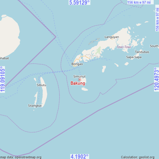
Bakung GPS coordinates[2]
4° 53' 27.996" North, 119° 47' 39.012" East
| Map corner | latitude | longitude |
|---|---|---|
| Upper-left | 5.59129°, | 119.09105° |
| Center: | 4.89111°, | 119.79417° |
| Lower-right: | 4.1902°, | 120.4973° |
| Map W x H: | 155.8×155.8 km | = 96.8×96.8mi |
| max Lat: | 20.78733° ⇑99.9% North |
| Bakung: | 4.89111° |
| min Lat: | ⇓0.1% South 4.65442° |
| min Long | Bakung | max Long |
| 117.04868° | 119.79417° | 126.58417° |
| W 1.5%⇐ | ⇒98.5% E |
Elevation
Elevation of Bakung is 7 m = 23 ft, and this is 80.9 m = 265 ft below average elevation for this country.
| Max E: |
2262 m = 7421 ft | 89.7% |
| Avg. | 87.9 m = 288 ft | |
| Bakung | 7 m = 23 ft | |
Min E: |
-2 m = -7 ft | 10.3% |
See also: Philippines elevation on elevation.city.
Geographical zone
Bakung is located in North Torrid zone (between Equator and Tropic of Cancer). Distance of Equator is 543.8 km =337.9 mi to South.| Distance of | km | miles | from Bakung |
|---|---|---|---|
| North Pole | 9463.2 | 5880.2 | to North |
| Arctic Circle | 6857.3 | 4260.9 | to North |
| Tropic Cancer | 2062.1 | 1281.3 | to North |
| Equator | 543.8 | 337.9 | to South |


Nearby cities:
15 places around Bakung: (largest is in red/bold)
• Balimbing
28.5 km =17.7 mi,  41°
41°
• Bankaw
27.7 km =17.2 mi,  59°
59°
• Bongao
15.5 km =9.6 mi,  351°
351°
• Kolape
22.9 km =14.2 mi,  29°
29°
• Lookan
37.8 km =23.5 mi, 64°
• Luuk Datan
10.5 km =6.5 mi,  147°
147°
• Manuk Mangkaw
11.9 km =7.4 mi, 148°
• New Batu Batu
21.9 km =13.6 mi, 26°
• Parangan
26.7 km =16.6 mi, 36°
• Sanga-Sanga
20.2 km =12.6 mi,  357°
357°
• Simunul
6.2 km =3.9 mi,  82°
82°
• Tampakan
3.5 km =2.2 mi, 359°
• Taungoh
39.2 km =24.4 mi,  238°
238°
• Tongouson
40.2 km =25 mi,  68°
68°
• Ungus-Ungus
18.5 km =11.5 mi,  15°
15°
Sources, notices
• [Note1] Compared only with cities in Philippines existing in our database
• [Src1] Map data: © OpenStreetMap contributors (CC-BY-SA)
• [Src2] Other city data from geonames.org with taken over terms of usage.
• [Src3] Geographical zone / Annual Mean Temperature by Robert A. Rohde @ Wikipedia
