Mangaldan geodata
Mangaldan (Ilocos) is a seat of a third-order administrative division; located in Philippines in Asia/Manila (GMT+8) time zone. With population of 88,818 people, there are 101 cities with bigger population in this country. Compared to other cities in Philippines, 88.4% of cities are located further ↓South; 93.7% of cities are located further →East and 85.4% of cities have higher elevation than Mangaldan. Note1


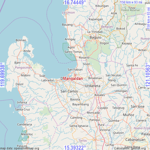
Mangaldan GPS coordinates[2]
16° 4' 12" North, 120° 24' 9" East
| Map corner | latitude | longitude |
|---|---|---|
| Upper-left | 16.74449°, | 119.69938° |
| Center: | 16.07°, | 120.4025° |
| Lower-right: | 15.39322°, | 121.10563° |
| Map W x H: | 150.2×150.3 km | = 93.3×93.4mi |
| max Lat: | 20.78733° ⇑11.6% North |
| Mangaldan: | 16.07° |
| min Lat: | ⇓88.4% South 4.65442° |
| min Long | Mangaldan | max Long |
| 117.04868° | 120.4025° | 126.58417° |
| W 6.3%⇐ | ⇒93.7% E |
Elevation
Elevation of Mangaldan is 8 m = 26 ft, and this is 79.9 m = 262 ft below average elevation for this country.
| Max E: |
2262 m = 7421 ft | 85.4% |
| Avg. | 87.9 m = 288 ft | |
| Mangaldan | 8 m = 26 ft | |
Min E: |
-2 m = -7 ft | 14.6% |
See also: Mangaldan elevation on elevation.city.
Geographical zone
Mangaldan is located in North Torrid zone (between Equator and Tropic of Cancer). Distance of this Northern Tropic circle is 819.1 km =509 mi to North.| Distance of | km | miles | from Mangaldan |
|---|---|---|---|
| North Pole | 8220.2 | 5107.8 | to North |
| Arctic Circle | 5614.4 | 3488.6 | to North |
| Tropic Cancer | 819.1 | 509 | to North |
| Equator | 1786.8 | 1110.3 | to South |


Nearby cities:
15 places around Mangaldan: (largest is in red/bold)
• Calasiao
8 km =5 mi,  214°
214°
• Cayanga
5 km =3.1 mi,  355°
355°
• Dagupan
8 km =5 mi,  248°
248°
• Labney
7.7 km =4.8 mi,  61°
61°
• Lobong
7.4 km =4.6 mi,  80°
80°
• Longos
4.2 km =2.6 mi,  351°
351°
• Macayug
4.1 km =2.5 mi,  50°
50°
• Malanay
6.9 km =4.3 mi,  173°
173°
• Mapandan
7.5 km =4.7 mi,  132°
132°
• Nibaliw Central
6.4 km =4 mi,  0°
0°
• Nilombot
5.7 km =3.5 mi,  140°
140°
• Sagud-Bahley
5.4 km =3.4 mi, 346°
• San Fabian
5.9 km =3.7 mi, 3°
• San Jacinto
3.8 km =2.4 mi,  85°
85°
• Santa Barbara
7.7 km =4.8 mi,  180°
180°
Sources, notices
• [Note1] Compared only with cities in Philippines existing in our database
• [Src1] Map data: © OpenStreetMap contributors (CC-BY-SA)
• [Src2] Other city data from geonames.org with taken over terms of usage.
• [Src3] Geographical zone / Annual Mean Temperature by Robert A. Rohde @ Wikipedia
