Lantangan geodata
Lantangan (Western Visayas) is a populated place; located in Philippines in Asia/Manila (GMT+8) time zone. With population of 2,252 people, there are 3785 cities with bigger population in this country. Compared to other cities in Philippines, 52.7% of cities are located further ↑North; 51.4% of cities are located further ←West and 80.1% of cities have lower elevation than Lantangan. Note1


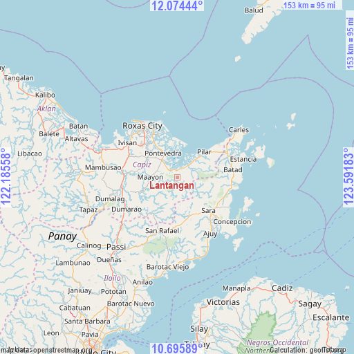
Lantangan GPS coordinates[2]
11° 23' 9.6" North, 122° 53' 19.32" East
| Map corner | latitude | longitude |
|---|---|---|
| Upper-left | 12.07444°, | 122.18558° |
| Center: | 11.386°, | 122.8887° |
| Lower-right: | 10.69589°, | 123.59183° |
| Map W x H: | 153.3×153.3 km | = 95.3×95.3mi |
| max Lat: | 20.78733° ⇑52.7% North |
| Lantangan: | 11.386° |
| min Lat: | ⇓47.3% South 4.65442° |
| min Long | Lantangan | max Long |
| 117.04868° | 122.8887° | 126.58417° |
| W 51.4%⇐ | ⇒48.6% E |
Elevation
Elevation of Lantangan is 93 m = 305 ft, and this is 5.1 m = 17 ft above average elevation for this country.
| Max E: |
2262 m = 7421 ft | 19.9% |
| Lantangan | 93 m 305 ft | |
| Avg. | 87.9 m = 288 ft | |
Min E: |
-2 m = -7 ft | 80.1% |
See also: Philippines elevation on elevation.city.
Geographical zone
Lantangan is located in North Torrid zone (between Equator and Tropic of Cancer). Distance of Equator is 1266 km =786.7 mi to South.| Distance of | km | miles | from Lantangan |
|---|---|---|---|
| North Pole | 8741.1 | 5431.5 | to North |
| Arctic Circle | 6135.2 | 3812.2 | to North |
| Tropic Cancer | 1339.9 | 832.6 | to North |
| Equator | 1266 | 786.7 | to South |


Nearby cities:
15 places around Lantangan: (largest is in red/bold)
• Bailan
10.3 km =6.4 mi,  321°
321°
• Binantocan
3.9 km =2.4 mi,  307°
307°
• Capaga
16.4 km =10.2 mi,  290°
290°
• Cogon
12.8 km =8 mi, 312°
• Dulangan
10.7 km =6.6 mi,  43°
43°
• Hipona
3.6 km =2.2 mi,  349°
349°
• Lacaron
16.5 km =10.3 mi,  284°
284°
• Maayon
11.2 km =7 mi,  270°
270°
• Panitan
15.5 km =9.6 mi, 305°
• Pilar
16.2 km =10.1 mi,  46°
46°
• Pontevedra
12.2 km =7.6 mi,  329°
329°
• President Roxas
6.6 km =4.1 mi, 40°
• Quipot
16.7 km =10.4 mi,  133°
133°
• Rizal
7.3 km =4.5 mi,  335°
335°
• Tabuc Pontevedra
13.4 km =8.3 mi, 324°
Sources, notices
• [Note1] Compared only with cities in Philippines existing in our database
• [Src1] Map data: © OpenStreetMap contributors (CC-BY-SA)
• [Src2] Other city data from geonames.org with taken over terms of usage.
• [Src3] Geographical zone / Annual Mean Temperature by Robert A. Rohde @ Wikipedia
