Bailan geodata
Bailan (Western Visayas) is a populated place; located in Philippines in Asia/Manila (GMT+8) time zone. With population of 2,885 people, there are 2660 cities with bigger population in this country. Compared to other cities in Philippines, 51.9% of cities are located further ↑North; 50.3% of cities are located further ←West and 89.7% of cities have higher elevation than Bailan. Note1


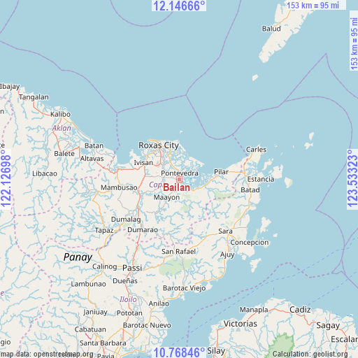
Bailan GPS coordinates[2]
11° 27' 30.24" North, 122° 49' 48.36" East
| Map corner | latitude | longitude |
|---|---|---|
| Upper-left | 12.14666°, | 122.12698° |
| Center: | 11.4584°, | 122.8301° |
| Lower-right: | 10.76846°, | 123.53323° |
| Map W x H: | 153.2×153.2 km | = 95.2×95.2mi |
| max Lat: | 20.78733° ⇑51.9% North |
| Bailan: | 11.4584° |
| min Lat: | ⇓48.1% South 4.65442° |
| min Long | Bailan | max Long |
| 117.04868° | 122.8301° | 126.58417° |
| W 50.3%⇐ | ⇒49.7% E |
Elevation
Elevation of Bailan is 7 m = 23 ft, and this is 80.9 m = 265 ft below average elevation for this country.
| Max E: |
2262 m = 7421 ft | 89.7% |
| Avg. | 87.9 m = 288 ft | |
| Bailan | 7 m = 23 ft | |
Min E: |
-2 m = -7 ft | 10.3% |
See also: Philippines elevation on elevation.city.
Geographical zone
Bailan is located in North Torrid zone (between Equator and Tropic of Cancer). Distance of Equator is 1274.1 km =791.7 mi to South.| Distance of | km | miles | from Bailan |
|---|---|---|---|
| North Pole | 8733 | 5426.4 | to North |
| Arctic Circle | 6127.1 | 3807.2 | to North |
| Tropic Cancer | 1331.9 | 827.6 | to North |
| Equator | 1274.1 | 791.7 | to South |


Nearby cities:
15 places around Bailan: (largest is in red/bold)
• Binantocan
6.6 km =4.1 mi,  149°
149°
• Capaga
9.2 km =5.7 mi,  255°
255°
• Cogon
3 km =1.9 mi,  282°
282°
• Hipona
7.3 km =4.5 mi,  128°
128°
• Intampilan
9.8 km =6.1 mi,  285°
285°
• Lacaron
10.4 km =6.5 mi,  247°
247°
• Lanot
10.4 km =6.5 mi,  310°
310°
• Lantangan
10.3 km =6.4 mi,  141°
141°
• Maayon
9.3 km =5.8 mi,  211°
211°
• Panitan
6.3 km =3.9 mi, 277°
• Pontevedra
2.5 km =1.6 mi,  5°
5°
• President Roxas
11.1 km =6.9 mi,  105°
105°
• Rizal
3.6 km =2.2 mi, 113°
• Tabuc Pontevedra
3.1 km =1.9 mi,  332°
332°
• Timpas
10.9 km =6.8 mi, 282°
Sources, notices
• [Note1] Compared only with cities in Philippines existing in our database
• [Src1] Map data: © OpenStreetMap contributors (CC-BY-SA)
• [Src2] Other city data from geonames.org with taken over terms of usage.
• [Src3] Geographical zone / Annual Mean Temperature by Robert A. Rohde @ Wikipedia
