Lun Pequeño geodata
Lun Pequeño (Soccsksargen) is a populated place; located in Philippines in Asia/Manila (GMT+8) time zone. With population of 11,541 people, there are 532 cities with bigger population in this country. Compared to other cities in Philippines, 97.6% of cities are located further ↑North; 91.1% of cities are located further ←West and 67.4% of cities have higher elevation than Lun Pequeño. Note1


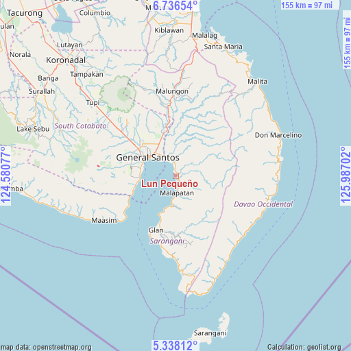
Lun Pequeño GPS coordinates[2]
6° 2' 16.008" North, 125° 17' 2.004" East
| Map corner | latitude | longitude |
|---|---|---|
| Upper-left | 6.73654°, | 124.58077° |
| Center: | 6.03778°, | 125.28389° |
| Lower-right: | 5.33812°, | 125.98702° |
| Map W x H: | 155.5×155.5 km | = 96.6×96.6mi |
| max Lat: | 20.78733° ⇑97.6% North |
| Lun Pequeño: | 6.03778° |
| min Lat: | ⇓2.4% South 4.65442° |
| min Long | Lun Pequeño | max Long |
| 117.04868° | 125.28389° | 126.58417° |
| W 91.1%⇐ | ⇒8.9% E |
Elevation
Elevation of Lun Pequeño is 13 m = 43 ft, and this is 74.9 m = 246 ft below average elevation for this country.
| Max E: |
2262 m = 7421 ft | 67.4% |
| Avg. | 87.9 m = 288 ft | |
| Lun Pequeño | 13 m = 43 ft | |
Min E: |
-2 m = -7 ft | 32.6% |
See also: Philippines elevation on elevation.city.
Geographical zone
Lun Pequeño is located in North Torrid zone (between Equator and Tropic of Cancer). Distance of Equator is 671.3 km =417.1 mi to South.| Distance of | km | miles | from Lun Pequeño |
|---|---|---|---|
| North Pole | 9335.7 | 5800.9 | to North |
| Arctic Circle | 6729.8 | 4181.7 | to North |
| Tropic Cancer | 1934.6 | 1202.1 | to North |
| Equator | 671.3 | 417.1 | to South |


Nearby cities:
15 places around Lun Pequeño: (largest is in red/bold)
• Alabel
7.2 km =4.5 mi,  5°
5°
• Batutitik
20.9 km =13 mi,  350°
350°
• Buayan
10.3 km =6.4 mi,  328°
328°
• Conel
21.2 km =13.2 mi, 329°
• General Santos
14.9 km =9.3 mi,  303°
303°
• Glan Peidu
21.6 km =13.4 mi,  199°
199°
• Kapatan
16.1 km =10 mi, 198°
• Katangawan
16.5 km =10.3 mi,  335°
335°
• Kiupo
22.2 km =13.8 mi,  169°
169°
• Malapatan
7.7 km =4.8 mi,  175°
175°
• Sapu Padidu
13.5 km =8.4 mi,  187°
187°
• Suyan
11.5 km =7.1 mi,  77°
77°
• Tañgo
18.7 km =11.6 mi, 201°
• Tinagacan
18.9 km =11.7 mi, 341°
• Tuyan
4.2 km =2.6 mi, 180°
Sources, notices
• [Note1] Compared only with cities in Philippines existing in our database
• [Src1] Map data: © OpenStreetMap contributors (CC-BY-SA)
• [Src2] Other city data from geonames.org with taken over terms of usage.
• [Src3] Geographical zone / Annual Mean Temperature by Robert A. Rohde @ Wikipedia
