Jagna geodata
Jagna (Central Visayas) is a seat of a third-order administrative division; located in Philippines in Asia/Manila (GMT+8) time zone. With population of 32,566 people, there are 261 cities with bigger population in this country. Compared to other cities in Philippines, 72.1% of cities are located further ↑North; 76.7% of cities are located further ←West and 95.5% of cities have higher elevation than Jagna. Note1


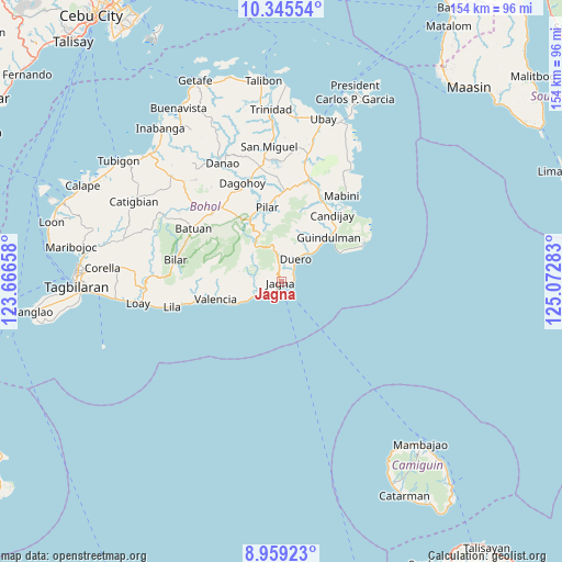
Jagna GPS coordinates[2]
9° 39' 11.16" North, 124° 22' 10.92" East
| Map corner | latitude | longitude |
|---|---|---|
| Upper-left | 10.34554°, | 123.66658° |
| Center: | 9.6531°, | 124.3697° |
| Lower-right: | 8.95923°, | 125.07283° |
| Map W x H: | 154.1×154.1 km | = 95.8×95.8mi |
| max Lat: | 20.78733° ⇑72.1% North |
| Jagna: | 9.6531° |
| min Lat: | ⇓27.9% South 4.65442° |
| min Long | Jagna | max Long |
| 117.04868° | 124.3697° | 126.58417° |
| W 76.7%⇐ | ⇒23.3% E |
Elevation
Elevation of Jagna is 5 m = 16 ft, and this is 82.9 m = 272 ft below average elevation for this country.
| Max E: |
2262 m = 7421 ft | 95.5% |
| Avg. | 87.9 m = 288 ft | |
| Jagna | 5 m = 16 ft | |
Min E: |
-2 m = -7 ft | 4.5% |
See also: Philippines elevation on elevation.city.
Geographical zone
Jagna is located in North Torrid zone (between Equator and Tropic of Cancer). Distance of Equator is 1073.3 km =666.9 mi to South.| Distance of | km | miles | from Jagna |
|---|---|---|---|
| North Pole | 8933.7 | 5551.1 | to North |
| Arctic Circle | 6327.8 | 3931.9 | to North |
| Tropic Cancer | 1532.6 | 952.3 | to North |
| Equator | 1073.3 | 666.9 | to South |


Nearby cities:
15 places around Jagna: (largest is in red/bold)
• Biabas
19.5 km =12.1 mi,  33°
33°
• Bugsoc
18.1 km =11.2 mi,  323°
323°
• Canhaway
15.6 km =9.7 mi,  46°
46°
• Canjulao
2 km =1.2 mi,  294°
294°
• Catungawan Sur
18 km =11.2 mi,  37°
37°
• Danao
18.7 km =11.6 mi,  263°
263°
• Duero
7.4 km =4.6 mi, 32°
• Estaca
11.6 km =7.2 mi, 292°
• Garcia Hernandez
9.3 km =5.8 mi,  242°
242°
• Guindulman
17.8 km =11.1 mi, 46°
• Lombog
14.9 km =9.3 mi,  20°
20°
• Mayana
11.6 km =7.2 mi,  350°
350°
• San Isidro
18.4 km =11.4 mi, 315°
• Sierra Bullones
19.2 km =11.9 mi,  333°
333°
• Valencia
18.4 km =11.4 mi,  254°
254°
Sources, notices
• [Note1] Compared only with cities in Philippines existing in our database
• [Src1] Map data: © OpenStreetMap contributors (CC-BY-SA)
• [Src2] Other city data from geonames.org with taken over terms of usage.
• [Src3] Geographical zone / Annual Mean Temperature by Robert A. Rohde @ Wikipedia
