Estaca geodata
Estaca (Central Visayas) is a populated place; located in Philippines in Asia/Manila (GMT+8) time zone. With population of 2,661 people, there are 3016 cities with bigger population in this country. Compared to other cities in Philippines, 71.7% of cities are located further ↑North; 75% of cities are located further ←West and 94.4% of cities have lower elevation than Estaca. Note1


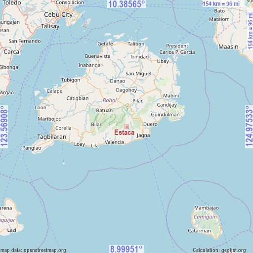
Estaca GPS coordinates[2]
9° 41' 35.88" North, 124° 16' 19.92" East
| Map corner | latitude | longitude |
|---|---|---|
| Upper-left | 10.38565°, | 123.56908° |
| Center: | 9.6933°, | 124.2722° |
| Lower-right: | 8.99951°, | 124.97533° |
| Map W x H: | 154.1×154.1 km | = 95.8×95.8mi |
| max Lat: | 20.78733° ⇑71.7% North |
| Estaca: | 9.6933° |
| min Lat: | ⇓28.3% South 4.65442° |
| min Long | Estaca | max Long |
| 117.04868° | 124.2722° | 126.58417° |
| W 75%⇐ | ⇒25% E |
Elevation
Elevation of Estaca is 386 m = 1266 ft, and this is 298.1 m = 978 ft above average elevation for this country.
| Max E: |
2262 m = 7421 ft | 5.6% |
| Estaca | 386 m 1266 ft | |
| Avg. | 87.9 m = 288 ft | |
Min E: |
-2 m = -7 ft | 94.4% |
See also: Philippines elevation on elevation.city.
Geographical zone
Estaca is located in North Torrid zone (between Equator and Tropic of Cancer). Distance of Equator is 1077.8 km =669.7 mi to South.| Distance of | km | miles | from Estaca |
|---|---|---|---|
| North Pole | 8929.3 | 5548.4 | to North |
| Arctic Circle | 6323.4 | 3929.2 | to North |
| Tropic Cancer | 1528.1 | 949.5 | to North |
| Equator | 1077.8 | 669.7 | to South |


Nearby cities:
15 places around Estaca: (largest is in red/bold)
• Bugsoc
10 km =6.2 mi,  359°
359°
• Canjulao
9.6 km =6 mi,  112°
112°
• Carmen
16.6 km =10.3 mi,  329°
329°
• Danao
10.3 km =6.4 mi,  229°
229°
• Dimiao
15.4 km =9.6 mi, 231°
• Duero
14.7 km =9.1 mi,  83°
83°
• Garcia Hernandez
9.1 km =5.7 mi,  164°
164°
• Jagna
11.6 km =7.2 mi, 112°
• Mayana
11.2 km =7 mi,  51°
51°
• Nueva Vida Sur
14.8 km =9.2 mi,  313°
313°
• Pilar
16.3 km =10.1 mi,  21°
21°
• San Isidro
8.9 km =5.5 mi,  346°
346°
• Sierra Bullones
12.9 km =8 mi,  9°
9°
• Valencia
11.7 km =7.3 mi,  217°
217°
• Valle Hermoso
11.9 km =7.4 mi,  340°
340°
Sources, notices
• [Note1] Compared only with cities in Philippines existing in our database
• [Src1] Map data: © OpenStreetMap contributors (CC-BY-SA)
• [Src2] Other city data from geonames.org with taken over terms of usage.
• [Src3] Geographical zone / Annual Mean Temperature by Robert A. Rohde @ Wikipedia
