Mayana geodata
Mayana (Central Visayas) is a populated place; located in Philippines in Asia/Manila (GMT+8) time zone. With population of 2,305 people, there are 3670 cities with bigger population in this country. Compared to other cities in Philippines, 70.9% of cities are located further ↑North; 76.6% of cities are located further ←West and 98.1% of cities have lower elevation than Mayana. Note1


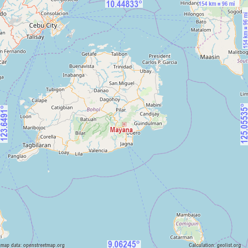
Mayana GPS coordinates[2]
9° 45' 21.996" North, 124° 21' 7.992" East
| Map corner | latitude | longitude |
|---|---|---|
| Upper-left | 10.44833°, | 123.6491° |
| Center: | 9.75611°, | 124.35222° |
| Lower-right: | 9.06245°, | 125.05535° |
| Map W x H: | 154.1×154.1 km | = 95.8×95.8mi |
| max Lat: | 20.78733° ⇑70.9% North |
| Mayana: | 9.75611° |
| min Lat: | ⇓29.1% South 4.65442° |
| min Long | Mayana | max Long |
| 117.04868° | 124.35222° | 126.58417° |
| W 76.6%⇐ | ⇒23.4% E |
Elevation
Elevation of Mayana is 751 m = 2464 ft, and this is 663.1 m = 2176 ft above average elevation for this country.
| Max E: |
2262 m = 7421 ft | 1.9% |
| Mayana | 751 m 2464 ft | |
| Avg. | 87.9 m = 288 ft | |
Min E: |
-2 m = -7 ft | 98.1% |
See also: Philippines elevation on elevation.city.
Geographical zone
Mayana is located in North Torrid zone (between Equator and Tropic of Cancer). Distance of Equator is 1084.8 km =674.1 mi to South.| Distance of | km | miles | from Mayana |
|---|---|---|---|
| North Pole | 8922.3 | 5544.1 | to North |
| Arctic Circle | 6316.4 | 3924.8 | to North |
| Tropic Cancer | 1521.1 | 945.2 | to North |
| Equator | 1084.8 | 674.1 | to South |


Nearby cities:
15 places around Mayana: (largest is in red/bold)
• Biabas
13.5 km =8.4 mi,  68°
68°
• Bugsoc
9.4 km =5.8 mi,  288°
288°
• Canhaway
13.2 km =8.2 mi,  92°
92°
• Canjulao
10.6 km =6.6 mi,  179°
179°
• Catungawan Sur
13.1 km =8.1 mi,  77°
77°
• Duero
7.8 km =4.8 mi,  131°
131°
• Estaca
11.2 km =7 mi,  231°
231°
• Jagna
11.6 km =7.2 mi,  170°
170°
• La Hacienda
14.6 km =9.1 mi,  17°
17°
• Lombog
7.6 km =4.7 mi, 70°
• Pilar
8.6 km =5.3 mi,  341°
341°
• San Isidro
11 km =6.8 mi,  278°
278°
• San Miguel
14.6 km =9.1 mi,  348°
348°
• Sierra Bullones
8.8 km =5.5 mi,  311°
311°
• Valle Hermoso
13.4 km =8.3 mi, 288°
Sources, notices
• [Note1] Compared only with cities in Philippines existing in our database
• [Src1] Map data: © OpenStreetMap contributors (CC-BY-SA)
• [Src2] Other city data from geonames.org with taken over terms of usage.
• [Src3] Geographical zone / Annual Mean Temperature by Robert A. Rohde @ Wikipedia
