Inapatan geodata
Inapatan (Bicol) is a populated place; located in Philippines in Asia/Manila (GMT+8) time zone. With population of 2,698 people, there are 2949 cities with bigger population in this country. Compared to other cities in Philippines, 61.1% of cities are located further ↓South; 58.8% of cities are located further ←West and 59.2% of cities have higher elevation than Inapatan. Note1


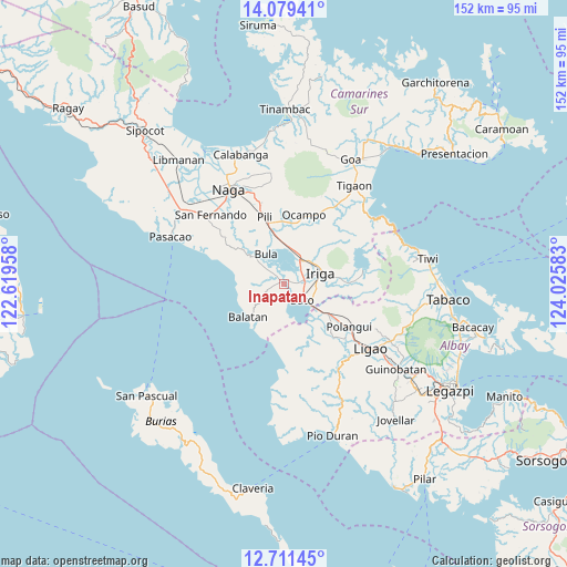
Inapatan GPS coordinates[2]
13° 23' 47.04" North, 123° 19' 21.72" East
| Map corner | latitude | longitude |
|---|---|---|
| Upper-left | 14.07941°, | 122.61958° |
| Center: | 13.3964°, | 123.3227° |
| Lower-right: | 12.71145°, | 124.02583° |
| Map W x H: | 152.1×152.1 km | = 94.5×94.5mi |
| max Lat: | 20.78733° ⇑38.9% North |
| Inapatan: | 13.3964° |
| min Lat: | ⇓61.1% South 4.65442° |
| min Long | Inapatan | max Long |
| 117.04868° | 123.3227° | 126.58417° |
| W 58.8%⇐ | ⇒41.2% E |
Elevation
Elevation of Inapatan is 17 m = 56 ft, and this is 70.9 m = 233 ft below average elevation for this country.
| Max E: |
2262 m = 7421 ft | 59.2% |
| Avg. | 87.9 m = 288 ft | |
| Inapatan | 17 m = 56 ft | |
Min E: |
-2 m = -7 ft | 40.8% |
See also: Philippines elevation on elevation.city.
Geographical zone
Inapatan is located in North Torrid zone (between Equator and Tropic of Cancer). Distance of this Northern Tropic circle is 1116.4 km =693.7 mi to North.| Distance of | km | miles | from Inapatan |
|---|---|---|---|
| North Pole | 8517.5 | 5292.5 | to North |
| Arctic Circle | 5911.6 | 3673.3 | to North |
| Tropic Cancer | 1116.4 | 693.7 | to North |
| Equator | 1489.5 | 925.5 | to South |


Nearby cities:
15 places around Inapatan: (largest is in red/bold)
• Agos
10.1 km =6.3 mi,  125°
125°
• Agupit
2.9 km =1.8 mi,  4°
4°
• Baao
8 km =5 mi,  35°
35°
• Balaogan
6 km =3.7 mi,  312°
312°
• Bato
6.9 km =4.3 mi, 134°
• Bula
9.5 km =5.9 mi,  329°
329°
• Del Rosario
10.1 km =6.3 mi,  185°
185°
• Lourdes
5.5 km =3.4 mi,  97°
97°
• Malawag
4.5 km =2.8 mi,  251°
251°
• Masoli
8.3 km =5.2 mi,  119°
119°
• Nabua
5.5 km =3.4 mi,  77°
77°
• Palsong
4.3 km =2.7 mi,  317°
317°
• Salvacion
9.4 km =5.8 mi, 38°
• San Miguel
9.6 km =6 mi,  74°
74°
• San Vicente
8.3 km =5.2 mi, 40°
Sources, notices
• [Note1] Compared only with cities in Philippines existing in our database
• [Src1] Map data: © OpenStreetMap contributors (CC-BY-SA)
• [Src2] Other city data from geonames.org with taken over terms of usage.
• [Src3] Geographical zone / Annual Mean Temperature by Robert A. Rohde @ Wikipedia
