Del Rosario geodata
Del Rosario (Bicol) is a populated place; located in Philippines in Asia/Manila (GMT+8) time zone. With population of 2,589 people, there are 3129 cities with bigger population in this country. Compared to other cities in Philippines, 60.1% of cities are located further ↓South; 58.6% of cities are located further ←West and 64.7% of cities have lower elevation than Del Rosario. Note1


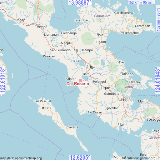
Del Rosario GPS coordinates[2]
13° 18' 20.52" North, 123° 18' 47.88" East
| Map corner | latitude | longitude |
|---|---|---|
| Upper-left | 13.98897°, | 122.61018° |
| Center: | 13.3057°, | 123.3133° |
| Lower-right: | 12.6205°, | 124.01643° |
| Map W x H: | 152.2×152.2 km | = 94.6×94.6mi |
| max Lat: | 20.78733° ⇑39.9% North |
| Del Rosario: | 13.3057° |
| min Lat: | ⇓60.1% South 4.65442° |
| min Long | Del Rosario | max Long |
| 117.04868° | 123.3133° | 126.58417° |
| W 58.6%⇐ | ⇒41.4% E |
Elevation
Elevation of Del Rosario is 41 m = 135 ft, and this is 46.9 m = 154 ft below average elevation for this country.
| Max E: |
2262 m = 7421 ft | 35.3% |
| Avg. | 87.9 m = 288 ft | |
| Del Rosario | 41 m = 135 ft | |
Min E: |
-2 m = -7 ft | 64.7% |
See also: Philippines elevation on elevation.city.
Geographical zone
Del Rosario is located in North Torrid zone (between Equator and Tropic of Cancer). Distance of this Northern Tropic circle is 1126.5 km =700 mi to North.| Distance of | km | miles | from Del Rosario |
|---|---|---|---|
| North Pole | 8527.6 | 5298.8 | to North |
| Arctic Circle | 5921.7 | 3679.6 | to North |
| Tropic Cancer | 1126.5 | 700 | to North |
| Equator | 1479.5 | 919.3 | to South |


Nearby cities:
15 places around Del Rosario: (largest is in red/bold)
• Agos
10.1 km =6.3 mi,  65°
65°
• Balatan
8.8 km =5.5 mi,  281°
281°
• Bato
7.9 km =4.9 mi,  48°
48°
• Buga
5.1 km =3.2 mi,  101°
101°
• Buluang
3.2 km =2 mi,  87°
87°
• Burabod
11.9 km =7.4 mi,  110°
110°
• Inapatan
10.1 km =6.3 mi,  5°
5°
• Lourdes
11.4 km =7.1 mi,  34°
34°
• Macabugos
7.8 km =4.8 mi,  186°
186°
• Malawag
9.2 km =5.7 mi,  339°
339°
• Masoli
10.2 km =6.3 mi, 54°
• Sagrada Familia
10 km =6.2 mi, 114°
• San Agustin
11.5 km =7.1 mi,  78°
78°
• San Jose
9.1 km =5.7 mi,  136°
136°
• Tambo
6.1 km =3.8 mi,  203°
203°
Sources, notices
• [Note1] Compared only with cities in Philippines existing in our database
• [Src1] Map data: © OpenStreetMap contributors (CC-BY-SA)
• [Src2] Other city data from geonames.org with taken over terms of usage.
• [Src3] Geographical zone / Annual Mean Temperature by Robert A. Rohde @ Wikipedia
