Guihulñgan geodata
Guihulñgan (Central Visayas) is a populated place; located in Philippines in Asia/Manila (GMT+8) time zone. With population of 22,931 people, there are 342 cities with bigger population in this country. Compared to other cities in Philippines, 67.2% of cities are located further ↑North; 57.8% of cities are located further ←West and 92.7% of cities have higher elevation than Guihulñgan. Note1
Administrative division(s):
- Level 1: Central Visayas
- Level 2: Province of Negros Oriental
- Level 3: City of Guihulngan


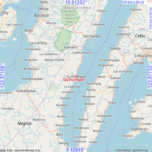
Guihulñgan GPS coordinates[2]
10° 7' 17.04" North, 123° 16' 27.12" East
| Map corner | latitude | longitude |
|---|---|---|
| Upper-left | 10.81282°, | 122.57108° |
| Center: | 10.1214°, | 123.2742° |
| Lower-right: | 9.42849°, | 123.97733° |
| Map W x H: | 153.9×153.9 km | = 95.6×95.6mi |
| max Lat: | 20.78733° ⇑67.2% North |
| Guihulñgan: | 10.1214° |
| min Lat: | ⇓32.8% South 4.65442° |
| min Long | Guihulñgan | max Long |
| 117.04868° | 123.2742° | 126.58417° |
| W 57.8%⇐ | ⇒42.2% E |
Elevation
Elevation of Guihulñgan is 6 m = 20 ft, and this is 81.9 m = 269 ft below average elevation for this country.
| Max E: |
2262 m = 7421 ft | 92.7% |
| Avg. | 87.9 m = 288 ft | |
| Guihulñgan | 6 m = 20 ft | |
Min E: |
-2 m = -7 ft | 7.3% |
See also: Philippines elevation on elevation.city.
Geographical zone
Guihulñgan is located in North Torrid zone (between Equator and Tropic of Cancer). Distance of Equator is 1125.4 km =699.3 mi to South.| Distance of | km | miles | from Guihulñgan |
|---|---|---|---|
| North Pole | 8881.7 | 5518.8 | to North |
| Arctic Circle | 6275.8 | 3899.6 | to North |
| Tropic Cancer | 1480.5 | 919.9 | to North |
| Equator | 1125.4 | 699.3 | to South |


Nearby cities:
15 places around Guihulñgan: (largest is in red/bold)
• Anopog
14.5 km =9 mi,  349°
349°
• Balogo
11.4 km =7.1 mi,  266°
266°
• Basak
12.2 km =7.6 mi,  16°
16°
• Buenavista
3.8 km =2.4 mi,  298°
298°
• Calamba
6.1 km =3.8 mi,  8°
8°
• Dumanjog
19.1 km =11.9 mi,  111°
111°
• Hibaiyo
17.6 km =10.9 mi, 16°
• Jimalalud
17.7 km =11 mi,  207°
207°
• La Libertad
11.4 km =7.1 mi,  202°
202°
• Malusay
2.5 km =1.6 mi, 353°
• McKinley
4.4 km =2.7 mi, 201°
• Padre Zamora
6.6 km =4.1 mi, 203°
• Saavedra
18.5 km =11.5 mi,  144°
144°
• Santa Cruz
19.9 km =12.4 mi,  129°
129°
• Tapon
19.8 km =12.3 mi, 109°
Sources, notices
• [Note1] Compared only with cities in Philippines existing in our database
• [Src1] Map data: © OpenStreetMap contributors (CC-BY-SA)
• [Src2] Other city data from geonames.org with taken over terms of usage.
• [Src3] Geographical zone / Annual Mean Temperature by Robert A. Rohde @ Wikipedia
