McKinley geodata
McKinley (Central Visayas) is a populated place; located in Philippines in Asia/Manila (GMT+8) time zone. With population of 2,213 people, there are 3861 cities with bigger population in this country. Compared to other cities in Philippines, 67.6% of cities are located further ↑North; 57.5% of cities are located further ←West and 67.4% of cities have higher elevation than McKinley. Note1
Administrative division(s):
- Level 1: Central Visayas
- Level 2: Province of Negros Oriental
- Level 3: City of Guihulngan


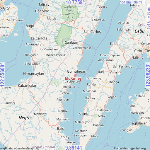
McKinley GPS coordinates[2]
10° 5' 3.84" North, 123° 15' 33.12" East
| Map corner | latitude | longitude |
|---|---|---|
| Upper-left | 10.7759°, | 122.55608° |
| Center: | 10.0844°, | 123.2592° |
| Lower-right: | 9.39141°, | 123.96233° |
| Map W x H: | 153.9×153.9 km | = 95.6×95.6mi |
| max Lat: | 20.78733° ⇑67.6% North |
| McKinley: | 10.0844° |
| min Lat: | ⇓32.4% South 4.65442° |
| min Long | McKinley | max Long |
| 117.04868° | 123.2592° | 126.58417° |
| W 57.5%⇐ | ⇒42.5% E |
Elevation
Elevation of McKinley is 13 m = 43 ft, and this is 74.9 m = 246 ft below average elevation for this country.
| Max E: |
2262 m = 7421 ft | 67.4% |
| Avg. | 87.9 m = 288 ft | |
| McKinley | 13 m = 43 ft | |
Min E: |
-2 m = -7 ft | 32.6% |
See also: Philippines elevation on elevation.city.
Geographical zone
McKinley is located in North Torrid zone (between Equator and Tropic of Cancer). Distance of Equator is 1121.3 km =696.7 mi to South.| Distance of | km | miles | from McKinley |
|---|---|---|---|
| North Pole | 8885.8 | 5521.4 | to North |
| Arctic Circle | 6279.9 | 3902.1 | to North |
| Tropic Cancer | 1484.6 | 922.5 | to North |
| Equator | 1121.3 | 696.7 | to South |


Nearby cities:
15 places around McKinley: (largest is in red/bold)
• Anopog
18.4 km =11.4 mi,  356°
356°
• Balogo
10.3 km =6.4 mi,  289°
289°
• Basak
16.6 km =10.3 mi,  18°
18°
• Basdiot
19.8 km =12.3 mi,  140°
140°
• Buenavista
6.2 km =3.9 mi,  344°
344°
• Calamba
10.4 km =6.5 mi,  14°
14°
• Dumanjog
19.6 km =12.2 mi,  98°
98°
• Guihulñgan
4.4 km =2.7 mi, 21°
• Jimalalud
13.3 km =8.3 mi,  209°
209°
• La Libertad
7 km =4.3 mi,  203°
203°
• Malusay
6.8 km =4.2 mi, 11°
• Padre Zamora
2.2 km =1.4 mi, 207°
• Ronda
19 km =11.8 mi,  119°
119°
• Saavedra
16.5 km =10.3 mi,  131°
131°
• Santa Cruz
19 km =11.8 mi, 116°
Sources, notices
• [Note1] Compared only with cities in Philippines existing in our database
• [Src1] Map data: © OpenStreetMap contributors (CC-BY-SA)
• [Src2] Other city data from geonames.org with taken over terms of usage.
• [Src3] Geographical zone / Annual Mean Temperature by Robert A. Rohde @ Wikipedia
