Guadalupe geodata
Guadalupe (Central Visayas) is a populated place; located in Philippines in Asia/Manila (GMT+8) time zone. With population of 4,061 people, there are 1690 cities with bigger population in this country. Compared to other cities in Philippines, 56.8% of cities are located further ↑North; 71.3% of cities are located further ←West and 62.2% of cities have lower elevation than Guadalupe. Note1
Administrative division(s):
- Level 1: Central Visayas
- Level 2: Province of Cebu
- Level 3: City of Bogo


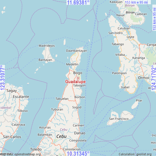
Guadalupe GPS coordinates[2]
11° 0' 15.984" North, 124° 0' 50.004" East
| Map corner | latitude | longitude |
|---|---|---|
| Upper-left | 11.69381°, | 123.31077° |
| Center: | 11.00444°, | 124.01389° |
| Lower-right: | 10.31345°, | 124.71702° |
| Map W x H: | 153.5×153.5 km | = 95.4×95.4mi |
| max Lat: | 20.78733° ⇑56.8% North |
| Guadalupe: | 11.00444° |
| min Lat: | ⇓43.2% South 4.65442° |
| min Long | Guadalupe | max Long |
| 117.04868° | 124.01389° | 126.58417° |
| W 71.3%⇐ | ⇒28.7% E |
Elevation
Elevation of Guadalupe is 37 m = 121 ft, and this is 50.9 m = 167 ft below average elevation for this country.
| Max E: |
2262 m = 7421 ft | 37.8% |
| Avg. | 87.9 m = 288 ft | |
| Guadalupe | 37 m = 121 ft | |
Min E: |
-2 m = -7 ft | 62.2% |
See also: Philippines elevation on elevation.city.
Geographical zone
Guadalupe is located in North Torrid zone (between Equator and Tropic of Cancer). Distance of Equator is 1223.6 km =760.3 mi to South.| Distance of | km | miles | from Guadalupe |
|---|---|---|---|
| North Pole | 8783.5 | 5457.8 | to North |
| Arctic Circle | 6177.6 | 3838.6 | to North |
| Tropic Cancer | 1382.3 | 858.9 | to North |
| Equator | 1223.6 | 760.3 | to South |


Nearby cities:
15 places around Guadalupe: (largest is in red/bold)
• Anonang
2.2 km =1.4 mi,  103°
103°
• Bogo
5.3 km =3.3 mi,  350°
350°
• Cayang
7.7 km =4.8 mi,  334°
334°
• Hagnaya
12.4 km =7.7 mi,  321°
321°
• Ilihan
12 km =7.5 mi,  203°
203°
• Lapaz
4.1 km =2.5 mi,  244°
244°
• Libertad
3 km =1.9 mi,  16°
16°
• Malingin
6.1 km =3.8 mi, 326°
• Maño
8.6 km =5.3 mi,  298°
298°
• Nailong
6.1 km =3.8 mi,  26°
26°
• San Remigio
11.9 km =7.4 mi, 315°
• Tabogon
7.2 km =4.5 mi,  167°
167°
• Tambongon
10.6 km =6.6 mi,  247°
247°
• Taytayan
14.5 km =9 mi, 196°
• Tindog
13.4 km =8.3 mi,  359°
359°
Sources, notices
• [Note1] Compared only with cities in Philippines existing in our database
• [Src1] Map data: © OpenStreetMap contributors (CC-BY-SA)
• [Src2] Other city data from geonames.org with taken over terms of usage.
• [Src3] Geographical zone / Annual Mean Temperature by Robert A. Rohde @ Wikipedia
