Taytayan geodata
Taytayan (Central Visayas) is a populated place; located in Philippines in Asia/Manila (GMT+8) time zone. With population of 3,654 people, there are 1945 cities with bigger population in this country. Compared to other cities in Philippines, 58.5% of cities are located further ↑North; 70.5% of cities are located further ←West and 86% of cities have lower elevation than Taytayan. Note1


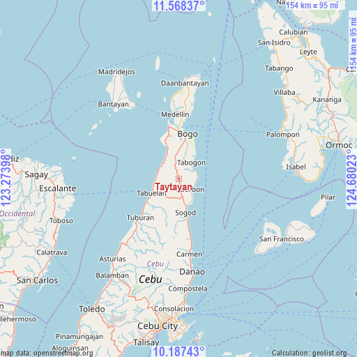
Taytayan GPS coordinates[2]
10° 52' 43.32" North, 123° 58' 37.56" East
| Map corner | latitude | longitude |
|---|---|---|
| Upper-left | 11.56837°, | 123.27398° |
| Center: | 10.8787°, | 123.9771° |
| Lower-right: | 10.18743°, | 124.68023° |
| Map W x H: | 153.5×153.6 km | = 95.4×95.4mi |
| max Lat: | 20.78733° ⇑58.5% North |
| Taytayan: | 10.8787° |
| min Lat: | ⇓41.5% South 4.65442° |
| min Long | Taytayan | max Long |
| 117.04868° | 123.9771° | 126.58417° |
| W 70.5%⇐ | ⇒29.5% E |
Elevation
Elevation of Taytayan is 151 m = 495 ft, and this is 63.1 m = 207 ft above average elevation for this country.
| Max E: |
2262 m = 7421 ft | 14% |
| Taytayan | 151 m 495 ft | |
| Avg. | 87.9 m = 288 ft | |
Min E: |
-2 m = -7 ft | 86% |
See also: Philippines elevation on elevation.city.
Geographical zone
Taytayan is located in North Torrid zone (between Equator and Tropic of Cancer). Distance of Equator is 1209.6 km =751.6 mi to South.| Distance of | km | miles | from Taytayan |
|---|---|---|---|
| North Pole | 8797.5 | 5466.5 | to North |
| Arctic Circle | 6191.6 | 3847.3 | to North |
| Tropic Cancer | 1396.3 | 867.6 | to North |
| Equator | 1209.6 | 751.6 | to South |


Nearby cities:
15 places around Taytayan: (largest is in red/bold)
• Borbon
7.3 km =4.5 mi,  128°
128°
• Calumboyan
11.2 km =7 mi,  150°
150°
• Campusong
9.2 km =5.7 mi,  139°
139°
• Damolog
12.2 km =7.6 mi,  164°
164°
• Guadalupe
14.5 km =9 mi,  16°
16°
• Ilihan
3.1 km =1.9 mi,  346°
346°
• Lapaz
12.2 km =7.6 mi,  1°
1°
• Lugo
7 km =4.3 mi,  171°
171°
• Maravilla
9.6 km =6 mi,  284°
284°
• Sogod
14.3 km =8.9 mi, 172°
• Tabogon
8.9 km =5.5 mi,  38°
38°
• Tabonok
11.4 km =7.1 mi,  254°
254°
• Tabuelan
13.5 km =8.4 mi,  241°
241°
• Tabunok
12.1 km =7.5 mi, 159°
• Tambongon
11.4 km =7.1 mi,  329°
329°
Sources, notices
• [Note1] Compared only with cities in Philippines existing in our database
• [Src1] Map data: © OpenStreetMap contributors (CC-BY-SA)
• [Src2] Other city data from geonames.org with taken over terms of usage.
• [Src3] Geographical zone / Annual Mean Temperature by Robert A. Rohde @ Wikipedia
