Tambongon geodata
Tambongon (Central Visayas) is a populated place; located in Philippines in Asia/Manila (GMT+8) time zone. With population of 2,643 people, there are 3038 cities with bigger population in this country. Compared to other cities in Philippines, 57.2% of cities are located further ↑North; 69.7% of cities are located further ←West and 80.7% of cities have higher elevation than Tambongon. Note1


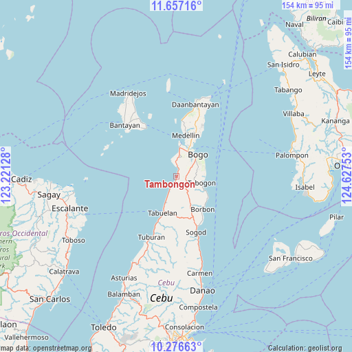
Tambongon GPS coordinates[2]
10° 58' 3.72" North, 123° 55' 27.84" East
| Map corner | latitude | longitude |
|---|---|---|
| Upper-left | 11.65716°, | 123.22128° |
| Center: | 10.9677°, | 123.9244° |
| Lower-right: | 10.27663°, | 124.62753° |
| Map W x H: | 153.5×153.5 km | = 95.4×95.4mi |
| max Lat: | 20.78733° ⇑57.2% North |
| Tambongon: | 10.9677° |
| min Lat: | ⇓42.8% South 4.65442° |
| min Long | Tambongon | max Long |
| 117.04868° | 123.9244° | 126.58417° |
| W 69.7%⇐ | ⇒30.3% E |
Elevation
Elevation of Tambongon is 9 m = 30 ft, and this is 78.9 m = 259 ft below average elevation for this country.
| Max E: |
2262 m = 7421 ft | 80.7% |
| Avg. | 87.9 m = 288 ft | |
| Tambongon | 9 m = 30 ft | |
Min E: |
-2 m = -7 ft | 19.3% |
See also: Philippines elevation on elevation.city.
Geographical zone
Tambongon is located in North Torrid zone (between Equator and Tropic of Cancer). Distance of Equator is 1219.5 km =757.8 mi to South.| Distance of | km | miles | from Tambongon |
|---|---|---|---|
| North Pole | 8787.6 | 5460.4 | to North |
| Arctic Circle | 6181.7 | 3841.1 | to North |
| Tropic Cancer | 1386.4 | 861.5 | to North |
| Equator | 1219.5 | 757.8 | to South |


Nearby cities:
15 places around Tambongon: (largest is in red/bold)
• Anonang
12.4 km =7.7 mi,  73°
73°
• Bogo
12.9 km =8 mi,  43°
43°
• Cayang
12.7 km =7.9 mi,  30°
30°
• Guadalupe
10.6 km =6.6 mi, 67°
• Hagnaya
14 km =8.7 mi,  8°
8°
• Ilihan
8.6 km =5.3 mi,  144°
144°
• Lapaz
6.5 km =4 mi, 68°
• Libertad
12.7 km =7.9 mi,  56°
56°
• Malingin
11.2 km =7 mi, 35°
• Maravilla
8.2 km =5.1 mi,  205°
205°
• Maño
8.5 km =5.3 mi,  15°
15°
• San Remigio
12.7 km =7.9 mi, 6°
• Tabogon
11.7 km =7.3 mi,  104°
104°
• Tabonok
14 km =8.7 mi,  201°
201°
• Taytayan
11.4 km =7.1 mi,  149°
149°
Sources, notices
• [Note1] Compared only with cities in Philippines existing in our database
• [Src1] Map data: © OpenStreetMap contributors (CC-BY-SA)
• [Src2] Other city data from geonames.org with taken over terms of usage.
• [Src3] Geographical zone / Annual Mean Temperature by Robert A. Rohde @ Wikipedia
