Gasan geodata
Gasan (Mimaropa) is a seat of a third-order administrative division; located in Philippines in Asia/Manila (GMT+8) time zone. With population of 2,228 people, there are 3830 cities with bigger population in this country. Compared to other cities in Philippines, 60.4% of cities are located further ↓South; 62.1% of cities are located further →East and 62.8% of cities have higher elevation than Gasan. Note1


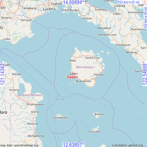
Gasan GPS coordinates[2]
13° 19' 25.392" North, 121° 50' 48.3" East
| Map corner | latitude | longitude |
|---|---|---|
| Upper-left | 14.00694°, | 121.14363° |
| Center: | 13.32372°, | 121.84675° |
| Lower-right: | 12.63857°, | 122.54988° |
| Map W x H: | 152.1×152.2 km | = 94.5×94.6mi |
| max Lat: | 20.78733° ⇑39.6% North |
| Gasan: | 13.32372° |
| min Lat: | ⇓60.4% South 4.65442° |
| min Long | Gasan | max Long |
| 117.04868° | 121.84675° | 126.58417° |
| W 37.9%⇐ | ⇒62.1% E |
Elevation
Elevation of Gasan is 15 m = 49 ft, and this is 72.9 m = 239 ft below average elevation for this country.
| Max E: |
2262 m = 7421 ft | 62.8% |
| Avg. | 87.9 m = 288 ft | |
| Gasan | 15 m = 49 ft | |
Min E: |
-2 m = -7 ft | 37.2% |
See also: Philippines elevation on elevation.city.
Geographical zone
Gasan is located in North Torrid zone (between Equator and Tropic of Cancer). Distance of this Northern Tropic circle is 1124.5 km =698.7 mi to North.| Distance of | km | miles | from Gasan |
|---|---|---|---|
| North Pole | 8525.6 | 5297.6 | to North |
| Arctic Circle | 5919.7 | 3678.3 | to North |
| Tropic Cancer | 1124.5 | 698.7 | to North |
| Equator | 1481.5 | 920.6 | to South |


Nearby cities:
15 places around Gasan: (largest is in red/bold)
• Balanacan
22.9 km =14.2 mi,  5°
5°
• Barangay of Poblacion
25.2 km =15.7 mi,  91°
91°
• Bintacay
19.7 km =12.2 mi, 9°
• Boac
13.6 km =8.5 mi,  356°
356°
• Buenavista
12.8 km =8 mi,  126°
126°
• Caigangan
11.9 km =7.4 mi, 127°
• Daykitin
9.1 km =5.7 mi, 130°
• Laylay
13.1 km =8.1 mi,  347°
347°
• Libas
14.9 km =9.3 mi, 127°
• Malibago
19.7 km =12.2 mi,  104°
104°
• Masiga
4.6 km =2.9 mi,  333°
333°
• Mogpog
16.8 km =10.4 mi, 5°
• Tigui
22 km =13.7 mi,  106°
106°
• Tiguion
2 km =1.2 mi,  51°
51°
• Yook
16.7 km =10.4 mi, 130°
Sources, notices
• [Note1] Compared only with cities in Philippines existing in our database
• [Src1] Map data: © OpenStreetMap contributors (CC-BY-SA)
• [Src2] Other city data from geonames.org with taken over terms of usage.
• [Src3] Geographical zone / Annual Mean Temperature by Robert A. Rohde @ Wikipedia
