Caigangan geodata
Caigangan (Mimaropa) is a populated place; located in Philippines in Asia/Manila (GMT+8) time zone. With population of 2,283 people, there are 3716 cities with bigger population in this country. Compared to other cities in Philippines, 59.5% of cities are located further ↓South; 61.1% of cities are located further →East and 73.2% of cities have higher elevation than Caigangan. Note1


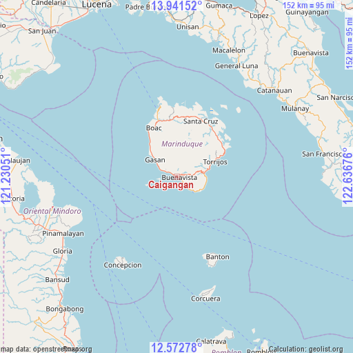
Caigangan GPS coordinates[2]
13° 15' 29.196" North, 121° 56' 1.068" East
| Map corner | latitude | longitude |
|---|---|---|
| Upper-left | 13.94152°, | 121.23051° |
| Center: | 13.25811°, | 121.93363° |
| Lower-right: | 12.57278°, | 122.63676° |
| Map W x H: | 152.2×152.2 km | = 94.6×94.6mi |
| max Lat: | 20.78733° ⇑40.5% North |
| Caigangan: | 13.25811° |
| min Lat: | ⇓59.5% South 4.65442° |
| min Long | Caigangan | max Long |
| 117.04868° | 121.93363° | 126.58417° |
| W 38.9%⇐ | ⇒61.1% E |
Elevation
Elevation of Caigangan is 11 m = 36 ft, and this is 76.9 m = 252 ft below average elevation for this country.
| Max E: |
2262 m = 7421 ft | 73.2% |
| Avg. | 87.9 m = 288 ft | |
| Caigangan | 11 m = 36 ft | |
Min E: |
-2 m = -7 ft | 26.8% |
See also: Philippines elevation on elevation.city.
Geographical zone
Caigangan is located in North Torrid zone (between Equator and Tropic of Cancer). Distance of this Northern Tropic circle is 1131.8 km =703.3 mi to North.| Distance of | km | miles | from Caigangan |
|---|---|---|---|
| North Pole | 8532.9 | 5302.1 | to North |
| Arctic Circle | 5927 | 3682.9 | to North |
| Tropic Cancer | 1131.8 | 703.3 | to North |
| Equator | 1474.2 | 916 | to South |


Nearby cities:
15 places around Caigangan: (largest is in red/bold)
• Barangay of Poblacion
17.1 km =10.6 mi,  67°
67°
• Boac
23.2 km =14.4 mi,  334°
334°
• Buenavista
0.9 km =0.6 mi,  111°
111°
• Daykitin
2.8 km =1.7 mi,  299°
299°
• Gasan
11.9 km =7.4 mi,  307°
307°
• Laylay
23.6 km =14.7 mi, 328°
• Libas
3 km =1.9 mi,  127°
127°
• Malibago
9.9 km =6.2 mi,  76°
76°
• Masiga
16.2 km =10.1 mi, 314°
• Mogpog
25.3 km =15.7 mi,  342°
342°
• Santa Cruz
26.2 km =16.3 mi,  22°
22°
• Tigui
11.7 km =7.3 mi, 84°
• Tiguion
11.6 km =7.2 mi,  317°
317°
• Torrijos
17.3 km =10.7 mi, 67°
• Yook
4.8 km =3 mi,  137°
137°
Sources, notices
• [Note1] Compared only with cities in Philippines existing in our database
• [Src1] Map data: © OpenStreetMap contributors (CC-BY-SA)
• [Src2] Other city data from geonames.org with taken over terms of usage.
• [Src3] Geographical zone / Annual Mean Temperature by Robert A. Rohde @ Wikipedia
