Gainza geodata
Gainza (Bicol) is a seat of a third-order administrative division; located in Philippines in Asia/Manila (GMT+8) time zone. With population of 2,173 people, there are 3941 cities with bigger population in this country. Compared to other cities in Philippines, 63.5% of cities are located further ↓South; 55.7% of cities are located further ←West and 98.1% of cities have higher elevation than Gainza. Note1


Gainza GPS coordinates[2]
13° 36' 59.4" North, 123° 8' 30.84" East
| Map corner | latitude | longitude |
|---|---|---|
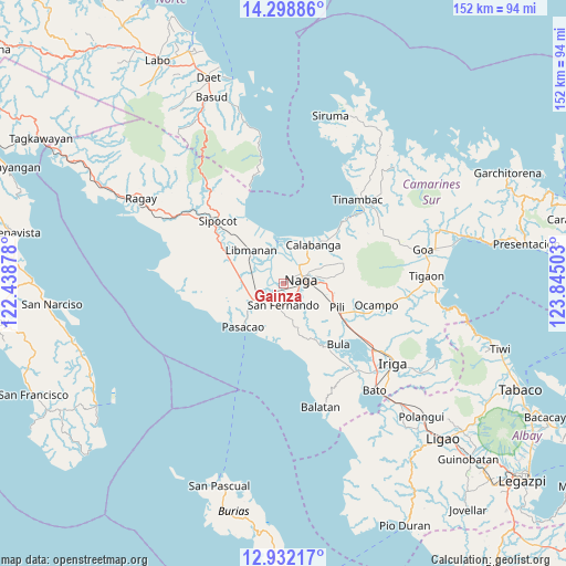
| Upper-left | 14.29886°, | 122.43878° |
| Center: | 13.6165°, | 123.1419° |
| Lower-right: | 12.93217°, | 123.84503° |
| Map W x H: | 152×152 km | = 94.4×94.4mi |
| max Lat: | 20.78733° ⇑36.5% North |
| Gainza: | 13.6165° |
| min Lat: | ⇓63.5% South 4.65442° |
| min Long | Gainza | max Long |
| 117.04868° | 123.1419° | 126.58417° |
| W 55.7%⇐ | ⇒44.3% E |
Elevation
Elevation of Gainza is 3 m = 10 ft, and this is 84.9 m = 279 ft below average elevation for this country.
| Max E: |
2262 m = 7421 ft | 98.1% |
| Avg. | 87.9 m = 288 ft | |
| Gainza | 3 m = 10 ft | |
Min E: |
-2 m = -7 ft | 1.9% |
See also: Philippines elevation on elevation.city.
Geographical zone
Gainza is located in North Torrid zone (between Equator and Tropic of Cancer). Distance of this Northern Tropic circle is 1091.9 km =678.5 mi to North.| Distance of | km | miles | from Gainza |
|---|---|---|---|
| North Pole | 8493 | 5277.3 | to North |
| Arctic Circle | 5887.2 | 3658.1 | to North |
| Tropic Cancer | 1091.9 | 678.5 | to North |
| Equator | 1514 | 940.8 | to South |


Nearby cities:
15 places around Gainza: (largest is in red/bold)
• Beberon
8 km =5 mi,  181°
181°
• Camaligan
2.8 km =1.7 mi,  76°
76°
• Canaman
4.6 km =2.9 mi,  40°
40°
• Capucnasan
8.3 km =5.2 mi,  102°
102°
• Dugcal
2.3 km =1.4 mi,  67°
67°
• Lupi
9.3 km =5.8 mi,  174°
174°
• Magarao
6.9 km =4.3 mi, 44°
• Marupit
2.9 km =1.8 mi, 66°
• Milaor
4.4 km =2.7 mi,  120°
120°
• Minalabac
7 km =4.3 mi,  139°
139°
• Naga
4.3 km =2.7 mi,  86°
86°
• Pamplona
7.1 km =4.4 mi,  246°
246°
• San Fernando
5.7 km =3.5 mi, 176°
• San Gabriel
7.2 km =4.5 mi,  219°
219°
• Santo Domingo
9.7 km =6 mi,  16°
16°
Sources, notices
• [Note1] Compared only with cities in Philippines existing in our database
• [Src1] Map data: © OpenStreetMap contributors (CC-BY-SA)
• [Src2] Other city data from geonames.org with taken over terms of usage.
• [Src3] Geographical zone / Annual Mean Temperature by Robert A. Rohde @ Wikipedia
