Canaman geodata
Canaman (Bicol) is a seat of a third-order administrative division; located in Philippines in Asia/Manila (GMT+8) time zone. With population of 3,010 people, there are 2517 cities with bigger population in this country. Compared to other cities in Philippines, 63.9% of cities are located further ↓South; 56.3% of cities are located further ←West and 98.1% of cities have higher elevation than Canaman. Note1


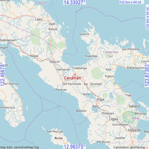
Canaman GPS coordinates[2]
13° 38' 52.8" North, 123° 10' 11.64" East
| Map corner | latitude | longitude |
|---|---|---|
| Upper-left | 14.33027°, | 122.46678° |
| Center: | 13.648°, | 123.1699° |
| Lower-right: | 12.96375°, | 123.87303° |
| Map W x H: | 151.9×151.9 km | = 94.4×94.4mi |
| max Lat: | 20.78733° ⇑36.1% North |
| Canaman: | 13.648° |
| min Lat: | ⇓63.9% South 4.65442° |
| min Long | Canaman | max Long |
| 117.04868° | 123.1699° | 126.58417° |
| W 56.3%⇐ | ⇒43.7% E |
Elevation
Elevation of Canaman is 3 m = 10 ft, and this is 84.9 m = 279 ft below average elevation for this country.
| Max E: |
2262 m = 7421 ft | 98.1% |
| Avg. | 87.9 m = 288 ft | |
| Canaman | 3 m = 10 ft | |
Min E: |
-2 m = -7 ft | 1.9% |
See also: Philippines elevation on elevation.city.
Geographical zone
Canaman is located in North Torrid zone (between Equator and Tropic of Cancer). Distance of this Northern Tropic circle is 1088.4 km =676.3 mi to North.| Distance of | km | miles | from Canaman |
|---|---|---|---|
| North Pole | 8489.5 | 5275.1 | to North |
| Arctic Circle | 5883.7 | 3656 | to North |
| Tropic Cancer | 1088.4 | 676.3 | to North |
| Equator | 1517.5 | 942.9 | to South |


Nearby cities:
15 places around Canaman: (largest is in red/bold)
• Bombon
6.1 km =3.8 mi,  42°
42°
• Calabanga
7.8 km =4.8 mi,  32°
32°
• Camaligan
2.9 km =1.8 mi,  186°
186°
• Capucnasan
7.4 km =4.6 mi,  136°
136°
• Dugcal
2.8 km =1.7 mi,  199°
199°
• Gainza
4.6 km =2.9 mi,  220°
220°
• Magarao
2.3 km =1.4 mi,  53°
53°
• Marupit
2.4 km =1.5 mi, 189°
• Milaor
5.8 km =3.6 mi,  172°
172°
• Minalabac
8.9 km =5.5 mi, 170°
• Naga
3.4 km =2.1 mi,  158°
158°
• Palestina
9.5 km =5.9 mi,  115°
115°
• San Lucas
7.4 km =4.6 mi, 29°
• San Vicente
6.6 km =4.1 mi, 29°
• Santo Domingo
5.8 km =3.6 mi,  356°
356°
Sources, notices
• [Note1] Compared only with cities in Philippines existing in our database
• [Src1] Map data: © OpenStreetMap contributors (CC-BY-SA)
• [Src2] Other city data from geonames.org with taken over terms of usage.
• [Src3] Geographical zone / Annual Mean Temperature by Robert A. Rohde @ Wikipedia
