Fabrica geodata
Fabrica (Bicol) is a populated place; located in Philippines in Asia/Manila (GMT+8) time zone. With population of 3,641 people, there are 1956 cities with bigger population in this country. Compared to other cities in Philippines, 62.1% of cities are located further ↓South; 58.2% of cities are located further ←West and 70.2% of cities have higher elevation than Fabrica. Note1


Fabrica GPS coordinates[2]
13° 29' 24" North, 123° 17' 38.4" East
| Map corner | latitude | longitude |
|---|---|---|
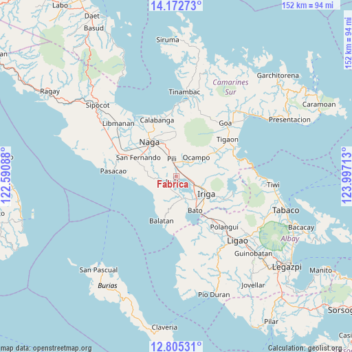
| Upper-left | 14.17273°, | 122.59088° |
| Center: | 13.49°, | 123.294° |
| Lower-right: | 12.80531°, | 123.99713° |
| Map W x H: | 152×152 km | = 94.4×94.4mi |
| max Lat: | 20.78733° ⇑37.9% North |
| Fabrica: | 13.49° |
| min Lat: | ⇓62.1% South 4.65442° |
| min Long | Fabrica | max Long |
| 117.04868° | 123.294° | 126.58417° |
| W 58.2%⇐ | ⇒41.8% E |
Elevation
Elevation of Fabrica is 12 m = 39 ft, and this is 75.9 m = 249 ft below average elevation for this country.
| Max E: |
2262 m = 7421 ft | 70.2% |
| Avg. | 87.9 m = 288 ft | |
| Fabrica | 12 m = 39 ft | |
Min E: |
-2 m = -7 ft | 29.8% |
See also: Philippines elevation on elevation.city.
Geographical zone
Fabrica is located in North Torrid zone (between Equator and Tropic of Cancer). Distance of this Northern Tropic circle is 1106 km =687.2 mi to North.| Distance of | km | miles | from Fabrica |
|---|---|---|---|
| North Pole | 8507.1 | 5286.1 | to North |
| Arctic Circle | 5901.2 | 3666.8 | to North |
| Tropic Cancer | 1106 | 687.2 | to North |
| Equator | 1499.9 | 932 | to South |


Nearby cities:
15 places around Fabrica: (largest is in red/bold)
• Agupit
8.2 km =5.1 mi,  156°
156°
• Ayugan
7 km =4.3 mi,  25°
25°
• Baao
8.6 km =5.3 mi,  116°
116°
• Bagumbayan
10.7 km =6.6 mi,  104°
104°
• Balaogan
6.5 km =4 mi,  191°
191°
• Baliuag Nuevo
10.6 km =6.6 mi,  289°
289°
• Bula
2.8 km =1.7 mi,  218°
218°
• Causip
3.1 km =1.9 mi,  338°
338°
• Himaao
6.1 km =3.8 mi,  6°
6°
• Inapatan
10.9 km =6.8 mi, 163°
• Palsong
7.3 km =4.5 mi,  178°
178°
• Pawili
3.2 km =2 mi, 338°
• Salvacion
9.4 km =5.8 mi,  108°
108°
• San Agustin
9.9 km =6.2 mi, 340°
• San Vicente
9.5 km =5.9 mi, 115°
Sources, notices
• [Note1] Compared only with cities in Philippines existing in our database
• [Src1] Map data: © OpenStreetMap contributors (CC-BY-SA)
• [Src2] Other city data from geonames.org with taken over terms of usage.
• [Src3] Geographical zone / Annual Mean Temperature by Robert A. Rohde @ Wikipedia
