Canlaon geodata
Canlaon (Central Visayas) is a populated place; located in Philippines in Asia/Manila (GMT+8) time zone. With population of 44,851 people, there are 194 cities with bigger population in this country. Compared to other cities in Philippines, 64.3% of cities are located further ↑North; 57% of cities are located further ←West and 95.7% of cities have lower elevation than Canlaon. Note1
Administrative division(s):
- Level 1: Central Visayas
- Level 2: Province of Negros Oriental
- Level 3: Canlaon City


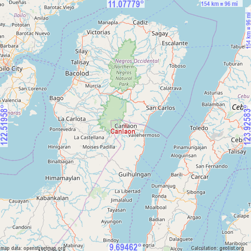
Canlaon GPS coordinates[2]
10° 23' 13.092" North, 123° 13' 21.72" East
| Map corner | latitude | longitude |
|---|---|---|
| Upper-left | 11.07779°, | 122.51958° |
| Center: | 10.38697°, | 123.2227° |
| Lower-right: | 9.69462°, | 123.92583° |
| Map W x H: | 153.8×153.8 km | = 95.6×95.6mi |
| max Lat: | 20.78733° ⇑64.3% North |
| Canlaon: | 10.38697° |
| min Lat: | ⇓35.7% South 4.65442° |
| min Long | Canlaon | max Long |
| 117.04868° | 123.2227° | 126.58417° |
| W 57%⇐ | ⇒43% E |
Elevation
Elevation of Canlaon is 479 m = 1572 ft, and this is 391.1 m = 1283 ft above average elevation for this country.
| Max E: |
2262 m = 7421 ft | 4.3% |
| Canlaon | 479 m 1572 ft | |
| Avg. | 87.9 m = 288 ft | |
Min E: |
-2 m = -7 ft | 95.7% |
See also: Canlaon elevation on elevation.city.
Geographical zone
Canlaon is located in North Torrid zone (between Equator and Tropic of Cancer). Distance of Equator is 1154.9 km =717.6 mi to South.| Distance of | km | miles | from Canlaon |
|---|---|---|---|
| North Pole | 8852.1 | 5500.4 | to North |
| Arctic Circle | 6246.3 | 3881.3 | to North |
| Tropic Cancer | 1451 | 901.6 | to North |
| Equator | 1154.9 | 717.6 | to South |


Nearby cities:
15 places around Canlaon: (largest is in red/bold)
• Anopog
15.5 km =9.6 mi,  168°
168°
• Buluangan
12.6 km =7.8 mi,  89°
89°
• Cabacungan
12.1 km =7.5 mi,  234°
234°
• Codcod
9 km =5.6 mi,  19°
19°
• Guba
9.5 km =5.9 mi,  149°
149°
• Hibaiyo
16.7 km =10.4 mi,  139°
139°
• Kumalisquis
13.5 km =8.4 mi,  350°
350°
• Malaiba
11.9 km =7.4 mi,  120°
120°
• Pinokawan
9.3 km =5.8 mi, 123°
• Prosperidad
17.1 km =10.6 mi,  33°
33°
• Quezon
6.9 km =4.3 mi,  37°
37°
• Sagang
16.7 km =10.4 mi,  260°
260°
• Tabon
14.7 km =9.1 mi,  129°
129°
• Vallehermoso
12.7 km =7.9 mi, 117°
• Yubo
16.8 km =10.4 mi,  270°
270°
Sources, notices
• [Note1] Compared only with cities in Philippines existing in our database
• [Src1] Map data: © OpenStreetMap contributors (CC-BY-SA)
• [Src2] Other city data from geonames.org with taken over terms of usage.
• [Src3] Geographical zone / Annual Mean Temperature by Robert A. Rohde @ Wikipedia
