Callaguip geodata
Callaguip (Ilocos) is a populated place; located in Philippines in Asia/Manila (GMT+8) time zone. With population of 2,105 people, there are 4064 cities with bigger population in this country. Compared to other cities in Philippines, 98.5% of cities are located further ↓South; 91.1% of cities are located further →East and 92.7% of cities have higher elevation than Callaguip. Note1


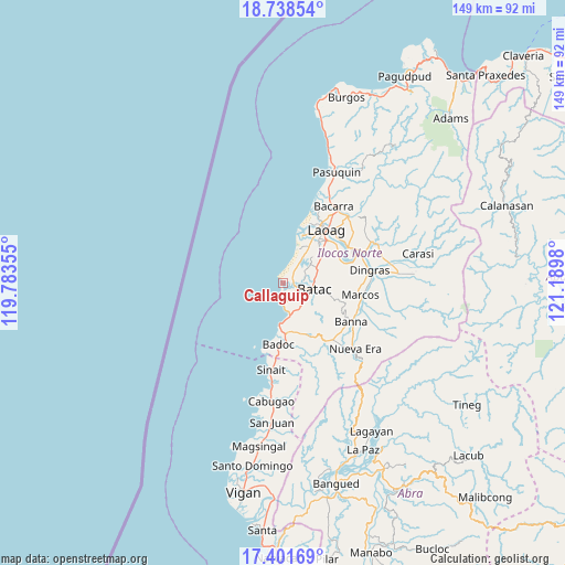
Callaguip GPS coordinates[2]
18° 4' 17.004" North, 120° 29' 12.012" East
| Map corner | latitude | longitude |
|---|---|---|
| Upper-left | 18.73854°, | 119.78355° |
| Center: | 18.07139°, | 120.48667° |
| Lower-right: | 17.40169°, | 121.1898° |
| Map W x H: | 148.6×148.6 km | = 92.3×92.3mi |
| max Lat: | 20.78733° ⇑1.5% North |
| Callaguip: | 18.07139° |
| min Lat: | ⇓98.5% South 4.65442° |
| min Long | Callaguip | max Long |
| 117.04868° | 120.48667° | 126.58417° |
| W 8.9%⇐ | ⇒91.1% E |
Elevation
Elevation of Callaguip is 6 m = 20 ft, and this is 81.9 m = 269 ft below average elevation for this country.
| Max E: |
2262 m = 7421 ft | 92.7% |
| Avg. | 87.9 m = 288 ft | |
| Callaguip | 6 m = 20 ft | |
Min E: |
-2 m = -7 ft | 7.3% |
See also: Philippines elevation on elevation.city.
Geographical zone
Callaguip is located in North Torrid zone (between Equator and Tropic of Cancer). Distance of this Northern Tropic circle is 596.6 km =370.7 mi to North.| Distance of | km | miles | from Callaguip |
|---|---|---|---|
| North Pole | 7997.7 | 4969.5 | to North |
| Arctic Circle | 5391.8 | 3350.3 | to North |
| Tropic Cancer | 596.6 | 370.7 | to North |
| Equator | 2009.4 | 1248.6 | to South |


Nearby cities:
15 places around Callaguip: (largest is in red/bold)
• Baay
10.7 km =6.6 mi,  60°
60°
• Badoc
16.1 km =10 mi,  183°
183°
• Batac City
8.5 km =5.3 mi,  102°
102°
• Bil-Loca
8.9 km =5.5 mi,  78°
78°
• Currimao
5.9 km =3.7 mi, 179°
• Laoag
18.2 km =11.3 mi,  39°
39°
• Mabusag
16.2 km =10.1 mi, 175°
• Nagbacalan
6.3 km =3.9 mi, 38°
• Pagsanahan Norte
17.5 km =10.9 mi,  194°
194°
• Paoay
3.9 km =2.4 mi,  106°
106°
• Pinili
14 km =8.7 mi,  161°
161°
• Quiling
6.1 km =3.8 mi,  93°
93°
• San Lorenzo
16.6 km =10.3 mi,  65°
65°
• San Nicolas
16.1 km =10 mi,  45°
45°
• Tabug
7.8 km =4.8 mi,  122°
122°
Sources, notices
• [Note1] Compared only with cities in Philippines existing in our database
• [Src1] Map data: © OpenStreetMap contributors (CC-BY-SA)
• [Src2] Other city data from geonames.org with taken over terms of usage.
• [Src3] Geographical zone / Annual Mean Temperature by Robert A. Rohde @ Wikipedia
