Butig geodata
Butig (Autonomous Region in Muslim Mindanao) is a seat of a third-order administrative division; located in Philippines in Asia/Manila (GMT+8) time zone. With population of 6,016 people, there are 1039 cities with bigger population in this country. Compared to other cities in Philippines, 85% of cities are located further ↑North; 75.5% of cities are located further ←West and 98.3% of cities have lower elevation than Butig. Note1
Administrative division(s):
- Level 1: Autonomous Region in Muslim Mindanao
- Level 2: Province of Lanao del Sur
- Level 3: Butig


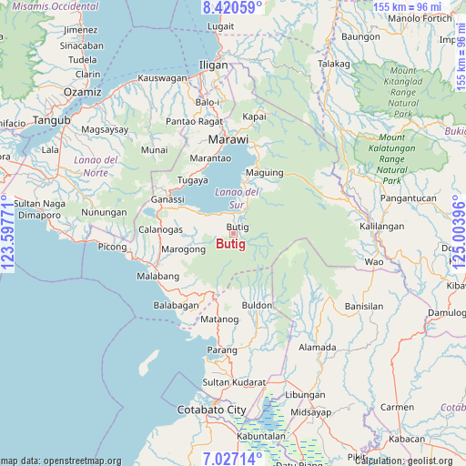
Butig GPS coordinates[2]
7° 43' 27.984" North, 124° 18' 2.988" East
| Map corner | latitude | longitude |
|---|---|---|
| Upper-left | 8.42059°, | 123.59771° |
| Center: | 7.72444°, | 124.30083° |
| Lower-right: | 7.02714°, | 125.00396° |
| Map W x H: | 154.9×154.9 km | = 96.3×96.3mi |
| max Lat: | 20.78733° ⇑85% North |
| Butig: | 7.72444° |
| min Lat: | ⇓15% South 4.65442° |
| min Long | Butig | max Long |
| 117.04868° | 124.30083° | 126.58417° |
| W 75.5%⇐ | ⇒24.5% E |
Elevation
Elevation of Butig is 793 m = 2602 ft, and this is 705.1 m = 2313 ft above average elevation for this country.
| Max E: |
2262 m = 7421 ft | 1.7% |
| Butig | 793 m 2602 ft | |
| Avg. | 87.9 m = 288 ft | |
Min E: |
-2 m = -7 ft | 98.3% |
See also: Philippines elevation on elevation.city.
Geographical zone
Butig is located in North Torrid zone (between Equator and Tropic of Cancer). Distance of Equator is 858.9 km =533.7 mi to South.| Distance of | km | miles | from Butig |
|---|---|---|---|
| North Pole | 9148.2 | 5684.4 | to North |
| Arctic Circle | 6542.3 | 4065.2 | to North |
| Tropic Cancer | 1747 | 1085.5 | to North |
| Equator | 858.9 | 533.7 | to South |


Nearby cities:
15 places around Butig: (largest is in red/bold)
• Bacayawan
8.8 km =5.5 mi,  302°
302°
• Bayang
14.2 km =8.8 mi, 302°
• Bayanga
23.2 km =14.4 mi,  193°
193°
• Binidayan
17.2 km =10.7 mi, 302°
• Bualan
4.7 km =2.9 mi,  307°
307°
• Calanogas
22.3 km =13.9 mi,  277°
277°
• Lumbac
5.4 km =3.4 mi, 281°
• Lumbatan
8.3 km =5.2 mi,  323°
323°
• Lumbayanague
6.9 km =4.3 mi,  340°
340°
• Marogong
17.8 km =11.1 mi,  248°
248°
• Masiu
9.9 km =6.2 mi,  10°
10°
• Matanog
23.7 km =14.7 mi, 191°
• Tamparan
17.6 km =10.9 mi, 11°
• Tubaran
15.5 km =9.6 mi,  287°
287°
• Tugaya
22.5 km =14 mi, 321°
Sources, notices
• [Note1] Compared only with cities in Philippines existing in our database
• [Src1] Map data: © OpenStreetMap contributors (CC-BY-SA)
• [Src2] Other city data from geonames.org with taken over terms of usage.
• [Src3] Geographical zone / Annual Mean Temperature by Robert A. Rohde @ Wikipedia
