Burabod geodata
Burabod (Bicol) is a populated place; located in Philippines in Asia/Manila (GMT+8) time zone. With population of 2,286 people, there are 3711 cities with bigger population in this country. Compared to other cities in Philippines, 59.6% of cities are located further ↓South; 60.7% of cities are located further ←West and 57.4% of cities have lower elevation than Burabod. Note1


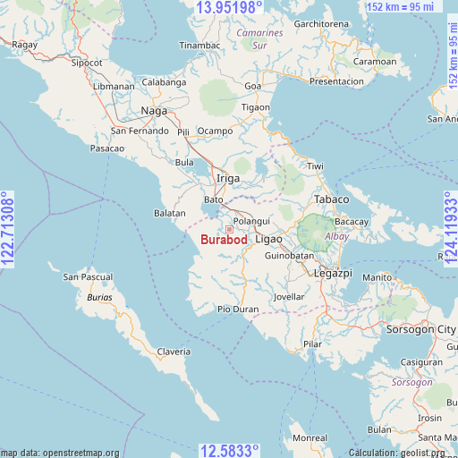
Burabod GPS coordinates[2]
13° 16' 6.96" North, 123° 24' 58.32" East
| Map corner | latitude | longitude |
|---|---|---|
| Upper-left | 13.95198°, | 122.71308° |
| Center: | 13.2686°, | 123.4162° |
| Lower-right: | 12.5833°, | 124.11933° |
| Map W x H: | 152.2×152.2 km | = 94.6×94.6mi |
| max Lat: | 20.78733° ⇑40.4% North |
| Burabod: | 13.2686° |
| min Lat: | ⇓59.6% South 4.65442° |
| min Long | Burabod | max Long |
| 117.04868° | 123.4162° | 126.58417° |
| W 60.7%⇐ | ⇒39.3% E |
Elevation
Elevation of Burabod is 30 m = 98 ft, and this is 57.9 m = 190 ft below average elevation for this country.
| Max E: |
2262 m = 7421 ft | 42.6% |
| Avg. | 87.9 m = 288 ft | |
| Burabod | 30 m = 98 ft | |
Min E: |
-2 m = -7 ft | 57.4% |
See also: Philippines elevation on elevation.city.
Geographical zone
Burabod is located in North Torrid zone (between Equator and Tropic of Cancer). Distance of this Northern Tropic circle is 1130.6 km =702.5 mi to North.| Distance of | km | miles | from Burabod |
|---|---|---|---|
| North Pole | 8531.7 | 5301.4 | to North |
| Arctic Circle | 5925.8 | 3682.1 | to North |
| Tropic Cancer | 1130.6 | 702.5 | to North |
| Equator | 1475.3 | 916.7 | to South |


Nearby cities:
15 places around Burabod: (largest is in red/bold)
• Agos
8.5 km =5.3 mi,  346°
346°
• Bato
10.7 km =6.6 mi,  330°
330°
• Buga
6.9 km =4.3 mi,  296°
296°
• Buluang
9 km =5.6 mi, 298°
• Lanigay
10.5 km =6.5 mi,  59°
59°
• Libon
4.2 km =2.6 mi,  35°
35°
• Manga
5 km =3.1 mi,  85°
85°
• Masoli
10.5 km =6.5 mi,  344°
344°
• Matacon
7 km =4.3 mi,  17°
17°
• Polangui
7.9 km =4.9 mi,  70°
70°
• Sagrada Familia
2 km =1.2 mi,  271°
271°
• San Agustin
6.4 km =4 mi,  1°
1°
• San Jose
5.5 km =3.4 mi,  242°
242°
• San Vicente
2 km =1.2 mi,  112°
112°
• Tinampo
10.8 km =6.7 mi, 114°
Sources, notices
• [Note1] Compared only with cities in Philippines existing in our database
• [Src1] Map data: © OpenStreetMap contributors (CC-BY-SA)
• [Src2] Other city data from geonames.org with taken over terms of usage.
• [Src3] Geographical zone / Annual Mean Temperature by Robert A. Rohde @ Wikipedia
