San Agustin geodata
San Agustin (Bicol) is a populated place; located in Philippines in Asia/Manila (GMT+8) time zone. With population of 4,551 people, there are 1466 cities with bigger population in this country. Compared to other cities in Philippines, 60.4% of cities are located further ↓South; 60.7% of cities are located further ←West and 62.8% of cities have higher elevation than San Agustin. Note1


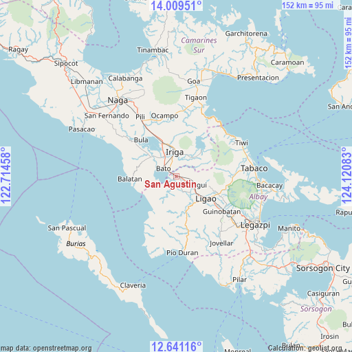
San Agustin GPS coordinates[2]
13° 19' 34.68" North, 123° 25' 3.72" East
| Map corner | latitude | longitude |
|---|---|---|
| Upper-left | 14.00951°, | 122.71458° |
| Center: | 13.3263°, | 123.4177° |
| Lower-right: | 12.64116°, | 124.12083° |
| Map W x H: | 152.1×152.1 km | = 94.5×94.5mi |
| max Lat: | 20.78733° ⇑39.6% North |
| San Agustin: | 13.3263° |
| min Lat: | ⇓60.4% South 4.65442° |
| min Long | San Agustin | max Long |
| 117.04868° | 123.4177° | 126.58417° |
| W 60.7%⇐ | ⇒39.3% E |
Elevation
Elevation of San Agustin is 15 m = 49 ft, and this is 72.9 m = 239 ft below average elevation for this country.
| Max E: |
2262 m = 7421 ft | 62.8% |
| Avg. | 87.9 m = 288 ft | |
| San Agustin | 15 m = 49 ft | |
Min E: |
-2 m = -7 ft | 37.2% |
See also: Philippines elevation on elevation.city.
Geographical zone
San Agustin is located in North Torrid zone (between Equator and Tropic of Cancer). Distance of this Northern Tropic circle is 1124.2 km =698.5 mi to North.| Distance of | km | miles | from San Agustin |
|---|---|---|---|
| North Pole | 8525.3 | 5297.4 | to North |
| Arctic Circle | 5919.4 | 3678.1 | to North |
| Tropic Cancer | 1124.2 | 698.5 | to North |
| Equator | 1481.7 | 920.7 | to South |


Nearby cities:
15 places around San Agustin: (largest is in red/bold)
• Agos
2.8 km =1.7 mi,  312°
312°
• Bato
6.2 km =3.9 mi,  298°
298°
• Buga
7.1 km =4.4 mi,  242°
242°
• Buluang
8.4 km =5.2 mi,  255°
255°
• Burabod
6.4 km =4 mi,  181°
181°
• Lanigay
9 km =5.6 mi,  96°
96°
• Libon
3.7 km =2.3 mi,  142°
142°
• Lourdes
8.5 km =5.3 mi,  325°
325°
• Manga
7.7 km =4.8 mi, 141°
• Masoli
4.8 km =3 mi,  320°
320°
• Matacon
2 km =1.2 mi,  83°
83°
• Polangui
8.3 km =5.2 mi,  117°
117°
• Sagrada Familia
6.7 km =4.2 mi,  198°
198°
• San Antonio
5 km =3.1 mi,  3°
3°
• San Vicente
7.4 km =4.6 mi,  166°
166°
Sources, notices
• [Note1] Compared only with cities in Philippines existing in our database
• [Src1] Map data: © OpenStreetMap contributors (CC-BY-SA)
• [Src2] Other city data from geonames.org with taken over terms of usage.
• [Src3] Geographical zone / Annual Mean Temperature by Robert A. Rohde @ Wikipedia
