Manga geodata
Manga (Bicol) is a populated place; located in Philippines in Asia/Manila (GMT+8) time zone. With population of 2,433 people, there are 3407 cities with bigger population in this country. Compared to other cities in Philippines, 59.7% of cities are located further ↓South; 61.5% of cities are located further ←West and 54.4% of cities have lower elevation than Manga. Note1


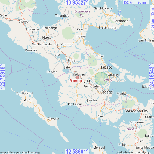
Manga GPS coordinates[2]
13° 16' 18.84" North, 123° 27' 44.28" East
| Map corner | latitude | longitude |
|---|---|---|
| Upper-left | 13.95527°, | 122.75918° |
| Center: | 13.2719°, | 123.4623° |
| Lower-right: | 12.58661°, | 124.16543° |
| Map W x H: | 152.2×152.2 km | = 94.6×94.6mi |
| max Lat: | 20.78733° ⇑40.3% North |
| Manga: | 13.2719° |
| min Lat: | ⇓59.7% South 4.65442° |
| min Long | Manga | max Long |
| 117.04868° | 123.4623° | 126.58417° |
| W 61.5%⇐ | ⇒38.5% E |
Elevation
Elevation of Manga is 27 m = 89 ft, and this is 60.9 m = 200 ft below average elevation for this country.
| Max E: |
2262 m = 7421 ft | 45.6% |
| Avg. | 87.9 m = 288 ft | |
| Manga | 27 m = 89 ft | |
Min E: |
-2 m = -7 ft | 54.4% |
See also: Philippines elevation on elevation.city.
Geographical zone
Manga is located in North Torrid zone (between Equator and Tropic of Cancer). Distance of this Northern Tropic circle is 1130.2 km =702.3 mi to North.| Distance of | km | miles | from Manga |
|---|---|---|---|
| North Pole | 8531.4 | 5301.2 | to North |
| Arctic Circle | 5925.5 | 3681.9 | to North |
| Tropic Cancer | 1130.2 | 702.3 | to North |
| Equator | 1475.7 | 917 | to South |


Nearby cities:
15 places around Manga: (largest is in red/bold)
• Balinad
9.3 km =5.8 mi,  75°
75°
• Balogo
9.6 km =6 mi, 79°
• Burabod
5 km =3.1 mi,  265°
265°
• City of Ligao
8.3 km =5.2 mi,  137°
137°
• Iraya
6.4 km =4 mi,  112°
112°
• Lanigay
6.4 km =4 mi,  39°
39°
• Libon
4 km =2.5 mi,  320°
320°
• Ligao
8.7 km =5.4 mi,  134°
134°
• Matacon
6.9 km =4.3 mi,  335°
335°
• Polangui
3.4 km =2.1 mi,  47°
47°
• Ponso
6.3 km =3.9 mi,  70°
70°
• Sagrada Familia
7 km =4.3 mi, 267°
• San Agustin
7.7 km =4.8 mi, 321°
• San Vicente
3.3 km =2.1 mi,  249°
249°
• Tinampo
6.9 km =4.3 mi, 134°
Sources, notices
• [Note1] Compared only with cities in Philippines existing in our database
• [Src1] Map data: © OpenStreetMap contributors (CC-BY-SA)
• [Src2] Other city data from geonames.org with taken over terms of usage.
• [Src3] Geographical zone / Annual Mean Temperature by Robert A. Rohde @ Wikipedia
