Buhi geodata
Buhi (Bicol) is a seat of a third-order administrative division; located in Philippines in Asia/Manila (GMT+8) time zone. With population of 30,126 people, there are 276 cities with bigger population in this country. Compared to other cities in Philippines, 61.5% of cities are located further ↓South; 62.5% of cities are located further ←West and 80.7% of cities have lower elevation than Buhi. Note1


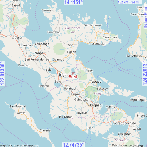
Buhi GPS coordinates[2]
13° 25' 55.92" North, 123° 31' 1.2" East
| Map corner | latitude | longitude |
|---|---|---|
| Upper-left | 14.1151°, | 122.81388° |
| Center: | 13.4322°, | 123.517° |
| Lower-right: | 12.74735°, | 124.22013° |
| Map W x H: | 152.1×152.1 km | = 94.5×94.5mi |
| max Lat: | 20.78733° ⇑38.5% North |
| Buhi: | 13.4322° |
| min Lat: | ⇓61.5% South 4.65442° |
| min Long | Buhi | max Long |
| 117.04868° | 123.517° | 126.58417° |
| W 62.5%⇐ | ⇒37.5% E |
Elevation
Elevation of Buhi is 96 m = 315 ft, and this is 8.1 m = 27 ft above average elevation for this country.
| Max E: |
2262 m = 7421 ft | 19.3% |
| Buhi | 96 m 315 ft | |
| Avg. | 87.9 m = 288 ft | |
Min E: |
-2 m = -7 ft | 80.7% |
See also: Philippines elevation on elevation.city.
Geographical zone
Buhi is located in North Torrid zone (between Equator and Tropic of Cancer). Distance of this Northern Tropic circle is 1112.4 km =691.2 mi to North.| Distance of | km | miles | from Buhi |
|---|---|---|---|
| North Pole | 8513.5 | 5290 | to North |
| Arctic Circle | 5907.7 | 3670.9 | to North |
| Tropic Cancer | 1112.4 | 691.2 | to North |
| Equator | 1493.5 | 928 | to South |


Nearby cities:
15 places around Buhi: (largest is in red/bold)
• Antipolo
4.4 km =2.7 mi,  171°
171°
• Bagumbayan
14.2 km =8.8 mi,  284°
284°
• Iriga City
11.4 km =7.1 mi,  270°
270°
• Joroan
12.7 km =7.9 mi,  60°
60°
• Lanigay
13 km =8.1 mi,  188°
188°
• Matacon
14.5 km =9 mi,  217°
217°
• Sagrada
12.9 km =8 mi,  327°
327°
• Salvacion
15.6 km =9.7 mi, 282°
• San Antonio
12.5 km =7.8 mi,  236°
236°
• San Jose
9.8 km =6.1 mi,  158°
158°
• San Miguel
11.8 km =7.3 mi,  263°
263°
• San Vicente
11 km =6.8 mi, 255°
• Santa Justina
6.2 km =3.9 mi,  230°
230°
• Santa Teresita
11.8 km =7.3 mi,  295°
295°
• Santo Domingo
7.5 km =4.7 mi, 259°
Sources, notices
• [Note1] Compared only with cities in Philippines existing in our database
• [Src1] Map data: © OpenStreetMap contributors (CC-BY-SA)
• [Src2] Other city data from geonames.org with taken over terms of usage.
• [Src3] Geographical zone / Annual Mean Temperature by Robert A. Rohde @ Wikipedia
