Bolong geodata
Bolong (Zamboanga Peninsula) is a populated place; located in Philippines in Asia/Manila (GMT+8) time zone. With population of 5,188 people, there are 1235 cities with bigger population in this country. Compared to other cities in Philippines, 90.8% of cities are located further ↑North; 57.8% of cities are located further →East and 92.7% of cities have higher elevation than Bolong. Note1
Administrative division(s):
- Level 1: Zamboanga Peninsula
- Level 2: Province of Zamboanga del Sur
- Level 3: Zamboanga City


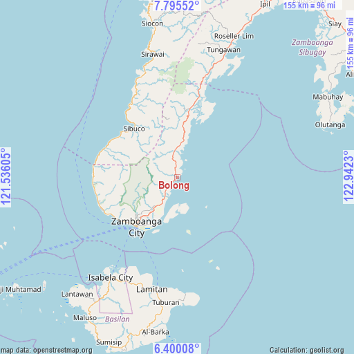
Bolong GPS coordinates[2]
7° 5' 53.988" North, 122° 14' 21.012" East
| Map corner | latitude | longitude |
|---|---|---|
| Upper-left | 7.79552°, | 121.53605° |
| Center: | 7.09833°, | 122.23917° |
| Lower-right: | 6.40008°, | 122.9423° |
| Map W x H: | 155.2×155.2 km | = 96.4×96.4mi |
| max Lat: | 20.78733° ⇑90.8% North |
| Bolong: | 7.09833° |
| min Lat: | ⇓9.2% South 4.65442° |
| min Long | Bolong | max Long |
| 117.04868° | 122.23917° | 126.58417° |
| W 42.2%⇐ | ⇒57.8% E |
Elevation
Elevation of Bolong is 6 m = 20 ft, and this is 81.9 m = 269 ft below average elevation for this country.
| Max E: |
2262 m = 7421 ft | 92.7% |
| Avg. | 87.9 m = 288 ft | |
| Bolong | 6 m = 20 ft | |
Min E: |
-2 m = -7 ft | 7.3% |
See also: Philippines elevation on elevation.city.
Geographical zone
Bolong is located in North Torrid zone (between Equator and Tropic of Cancer). Distance of Equator is 789.3 km =490.4 mi to South.| Distance of | km | miles | from Bolong |
|---|---|---|---|
| North Pole | 9217.8 | 5727.7 | to North |
| Arctic Circle | 6611.9 | 4108.4 | to North |
| Tropic Cancer | 1816.7 | 1128.8 | to North |
| Equator | 789.3 | 490.4 | to South |


Nearby cities:
15 places around Bolong: (largest is in red/bold)
• Buenavista
15.4 km =9.6 mi,  6°
6°
• Bunguiao
4.8 km =3 mi,  278°
278°
• Cabaluay
12.6 km =7.8 mi,  211°
211°
• Calabasa
16.5 km =10.3 mi,  358°
358°
• Culianan
16.6 km =10.3 mi,  217°
217°
• Curuan
11.9 km =7.4 mi, 356°
• Dulian
7.1 km =4.4 mi,  291°
291°
• Lamisahan
9.4 km =5.8 mi,  251°
251°
• Landang Laum
14.4 km =8.9 mi,  175°
175°
• Manicahan
9.7 km =6 mi, 205°
• Mercedes
18.5 km =11.5 mi, 212°
• Quinipot
9.3 km =5.8 mi,  347°
347°
• Sangali
5.3 km =3.3 mi,  232°
232°
• Taluksangay
17.2 km =10.7 mi,  200°
200°
• Tolosa
11.3 km =7 mi, 229°
Sources, notices
• [Note1] Compared only with cities in Philippines existing in our database
• [Src1] Map data: © OpenStreetMap contributors (CC-BY-SA)
• [Src2] Other city data from geonames.org with taken over terms of usage.
• [Src3] Geographical zone / Annual Mean Temperature by Robert A. Rohde @ Wikipedia
