Tolosa geodata
Tolosa (Zamboanga Peninsula) is a populated place; located in Philippines in Asia/Manila (GMT+8) time zone. With population of 2,686 people, there are 2970 cities with bigger population in this country. Compared to other cities in Philippines, 91.4% of cities are located further ↑North; 58.4% of cities are located further →East and 82.2% of cities have lower elevation than Tolosa. Note1
Administrative division(s):
- Level 1: Zamboanga Peninsula
- Level 2: Province of Zamboanga del Sur
- Level 3: Zamboanga City


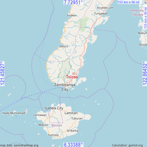
Tolosa GPS coordinates[2]
7° 1' 55.992" North, 122° 9' 41.004" East
| Map corner | latitude | longitude |
|---|---|---|
| Upper-left | 7.72951°, | 121.45827° |
| Center: | 7.03222°, | 122.16139° |
| Lower-right: | 6.33388°, | 122.86452° |
| Map W x H: | 155.2×155.2 km | = 96.4×96.4mi |
| max Lat: | 20.78733° ⇑91.4% North |
| Tolosa: | 7.03222° |
| min Lat: | ⇓8.6% South 4.65442° |
| min Long | Tolosa | max Long |
| 117.04868° | 122.16139° | 126.58417° |
| W 41.6%⇐ | ⇒58.4% E |
Elevation
Elevation of Tolosa is 108 m = 354 ft, and this is 20.1 m = 66 ft above average elevation for this country.
| Max E: |
2262 m = 7421 ft | 17.8% |
| Tolosa | 108 m 354 ft | |
| Avg. | 87.9 m = 288 ft | |
Min E: |
-2 m = -7 ft | 82.2% |
See also: Philippines elevation on elevation.city.
Geographical zone
Tolosa is located in North Torrid zone (between Equator and Tropic of Cancer). Distance of Equator is 781.9 km =485.8 mi to South.| Distance of | km | miles | from Tolosa |
|---|---|---|---|
| North Pole | 9225.2 | 5732.3 | to North |
| Arctic Circle | 6619.3 | 4113 | to North |
| Tropic Cancer | 1824 | 1133.4 | to North |
| Equator | 781.9 | 485.8 | to South |


Nearby cities:
15 places around Tolosa: (largest is in red/bold)
• Bolong
11.3 km =7 mi,  49°
49°
• Bunguiao
8.9 km =5.5 mi,  25°
25°
• Cabaluay
4 km =2.5 mi,  148°
148°
• Culianan
6 km =3.7 mi,  195°
195°
• Dulian
10.1 km =6.3 mi,  11°
11°
• Lamisahan
4.3 km =2.7 mi,  355°
355°
• Landang Laum
12 km =7.5 mi,  126°
126°
• Lumbayan
9.7 km =6 mi,  193°
193°
• Manicahan
4.6 km =2.9 mi,  107°
107°
• Mercedes
8.3 km =5.2 mi, 189°
• Sangali
6.1 km =3.8 mi, 46°
• Talabaan
10.2 km =6.3 mi,  173°
173°
• Taluksangay
9 km =5.6 mi,  164°
164°
• Tigtabon
15.2 km =9.4 mi,  177°
177°
• Zamboanga
16.6 km =10.3 mi,  215°
215°
Sources, notices
• [Note1] Compared only with cities in Philippines existing in our database
• [Src1] Map data: © OpenStreetMap contributors (CC-BY-SA)
• [Src2] Other city data from geonames.org with taken over terms of usage.
• [Src3] Geographical zone / Annual Mean Temperature by Robert A. Rohde @ Wikipedia
