Bolo geodata
Bolo (Ilocos) is a populated place; located in Philippines in Asia/Manila (GMT+8) time zone. With population of 2,784 people, there are 2813 cities with bigger population in this country. Compared to other cities in Philippines, 87.5% of cities are located further ↓South; 96.3% of cities are located further →East and 73.2% of cities have higher elevation than Bolo. Note1


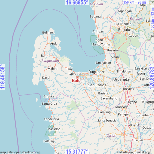
Bolo GPS coordinates[2]
15° 59' 41.28" North, 120° 9' 52.92" East
| Map corner | latitude | longitude |
|---|---|---|
| Upper-left | 16.66955°, | 119.46158° |
| Center: | 15.9948°, | 120.1647° |
| Lower-right: | 15.31777°, | 120.86783° |
| Map W x H: | 150.3×150.3 km | = 93.4×93.4mi |
| max Lat: | 20.78733° ⇑12.5% North |
| Bolo: | 15.9948° |
| min Lat: | ⇓87.5% South 4.65442° |
| min Long | Bolo | max Long |
| 117.04868° | 120.1647° | 126.58417° |
| W 3.7%⇐ | ⇒96.3% E |
Elevation
Elevation of Bolo is 11 m = 36 ft, and this is 76.9 m = 252 ft below average elevation for this country.
| Max E: |
2262 m = 7421 ft | 73.2% |
| Avg. | 87.9 m = 288 ft | |
| Bolo | 11 m = 36 ft | |
Min E: |
-2 m = -7 ft | 26.8% |
See also: Philippines elevation on elevation.city.
Geographical zone
Bolo is located in North Torrid zone (between Equator and Tropic of Cancer). Distance of this Northern Tropic circle is 827.5 km =514.2 mi to North.| Distance of | km | miles | from Bolo |
|---|---|---|---|
| North Pole | 8228.6 | 5113 | to North |
| Arctic Circle | 5622.7 | 3493.8 | to North |
| Tropic Cancer | 827.5 | 514.2 | to North |
| Equator | 1778.5 | 1105.1 | to South |


Nearby cities:
15 places around Bolo: (largest is in red/bold)
• Boñgalon
0.9 km =0.6 mi,  314°
314°
• Bugallon
7.2 km =4.5 mi,  130°
130°
• Domalanoan
5.1 km =3.2 mi,  79°
79°
• Dulig
0.9 km =0.6 mi,  27°
27°
• Hacienda
6.7 km =4.2 mi,  167°
167°
• Labrador
4.3 km =2.7 mi,  329°
329°
• Laguit Centro
6 km =3.7 mi,  152°
152°
• Lingayen
7.8 km =4.8 mi,  67°
67°
• Magtaking
2.2 km =1.4 mi,  117°
117°
• Naguelguel
10.6 km =6.6 mi, 83°
• Polong
4.3 km =2.7 mi, 116°
• Sual
11 km =6.8 mi,  316°
316°
• Tobuan
8.9 km =5.5 mi, 319°
• Umanday Centro
8.3 km =5.2 mi,  139°
139°
• Uyong
7.7 km =4.8 mi, 322°
Sources, notices
• [Note1] Compared only with cities in Philippines existing in our database
• [Src1] Map data: © OpenStreetMap contributors (CC-BY-SA)
• [Src2] Other city data from geonames.org with taken over terms of usage.
• [Src3] Geographical zone / Annual Mean Temperature by Robert A. Rohde @ Wikipedia
