Naguelguel geodata
Naguelguel (Ilocos) is a populated place; located in Philippines in Asia/Manila (GMT+8) time zone. With population of 3,124 people, there are 2391 cities with bigger population in this country. Compared to other cities in Philippines, 87.7% of cities are located further ↓South; 95.7% of cities are located further →East and 92.7% of cities have higher elevation than Naguelguel. Note1


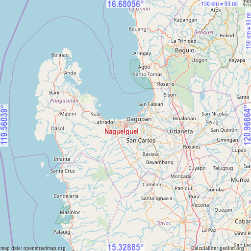
Naguelguel GPS coordinates[2]
16° 0' 21.06" North, 120° 15' 48.636" East
| Map corner | latitude | longitude |
|---|---|---|
| Upper-left | 16.68056°, | 119.56039° |
| Center: | 16.00585°, | 120.26351° |
| Lower-right: | 15.32885°, | 120.96664° |
| Map W x H: | 150.3×150.3 km | = 93.4×93.4mi |
| max Lat: | 20.78733° ⇑12.3% North |
| Naguelguel: | 16.00585° |
| min Lat: | ⇓87.7% South 4.65442° |
| min Long | Naguelguel | max Long |
| 117.04868° | 120.26351° | 126.58417° |
| W 4.3%⇐ | ⇒95.7% E |
Elevation
Elevation of Naguelguel is 6 m = 20 ft, and this is 81.9 m = 269 ft below average elevation for this country.
| Max E: |
2262 m = 7421 ft | 92.7% |
| Avg. | 87.9 m = 288 ft | |
| Naguelguel | 6 m = 20 ft | |
Min E: |
-2 m = -7 ft | 7.3% |
See also: Philippines elevation on elevation.city.
Geographical zone
Naguelguel is located in North Torrid zone (between Equator and Tropic of Cancer). Distance of this Northern Tropic circle is 826.2 km =513.4 mi to North.| Distance of | km | miles | from Naguelguel |
|---|---|---|---|
| North Pole | 8227.4 | 5112.3 | to North |
| Arctic Circle | 5621.5 | 3493 | to North |
| Tropic Cancer | 826.2 | 513.4 | to North |
| Equator | 1779.7 | 1105.9 | to South |


Nearby cities:
15 places around Naguelguel: (largest is in red/bold)
• Balogo
2.7 km =1.7 mi,  129°
129°
• Basing
2.4 km =1.5 mi,  167°
167°
• Binmaley
3 km =1.9 mi,  11°
11°
• Bugallon
7.8 km =4.8 mi,  221°
221°
• Calomboyan
7.9 km =4.9 mi,  147°
147°
• Camaley
4.1 km =2.5 mi,  103°
103°
• Canaoalan
4.4 km =2.7 mi,  53°
53°
• Domalanoan
5.6 km =3.5 mi,  266°
266°
• Gayaman
4.8 km =3 mi,  79°
79°
• Lingayen
3.8 km =2.4 mi,  297°
297°
• Malawa
5.5 km =3.4 mi,  163°
163°
• Nagsaing
8.4 km =5.2 mi,  109°
109°
• Naguilayan
3 km =1.9 mi, 96°
• Polong
7.4 km =4.6 mi,  244°
244°
• Quintong
8.3 km =5.2 mi, 131°
Sources, notices
• [Note1] Compared only with cities in Philippines existing in our database
• [Src1] Map data: © OpenStreetMap contributors (CC-BY-SA)
• [Src2] Other city data from geonames.org with taken over terms of usage.
• [Src3] Geographical zone / Annual Mean Temperature by Robert A. Rohde @ Wikipedia
